Legionslager_Carnuntum_Uebersichtsplan.jpg

Size of this preview:
519 × 600 pixels
.
Other resolutions:
208 × 240 pixels
|
415 × 480 pixels
|
649 × 750 pixels
.

|
This
architecture
image could be re-created
using
vector graphics
as an
SVG
file
. This has several advantages; see
Commons:Media for cleanup
for more information. If an SVG form of this image is available, please upload it and afterwards replace this template with
{{

vector version available

|

new image name

}}
.
It is recommended to name the SVG file “Legionslager Carnuntum Uebersichtsplan.svg”—then the template Vector version available (or Vva ) does not need the new image name parameter. |


Summary
| Description |
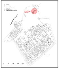
Legionslager Carnuntum: Übersichtsplan (aus Becker, G. & Harl, O. 1983. Archäologie in Österreich) 1. Principia, 2. Praetorium, 3. Tribunenhäuser, 4. Kasernen, 5. Lazarett, 6. Werkstätten und Speicherbauten. |
| Date |
30 August 2007 (original upload date)
|
| Source |
Transferred from
de.wikipedia
to Commons.
|
| Author |
Archaeotux
at
German Wikipedia
|
| Other versions | Italian png version |
| Object location |
|
View this and other nearby images on: OpenStreetMap |
|
|---|
Licensing

|
Permission is granted to copy, distribute and/or modify this document under the terms of the GNU Free Documentation License , Version 1.2 or any later version published by the Free Software Foundation ; with no Invariant Sections, no Front-Cover Texts, and no Back-Cover Texts. A copy of the license is included in the section entitled GNU Free Documentation License . |
Original upload log
The original description page was
here
. All following user names refer to de.wikipedia.
- 2007-08-30 11:43 Archaeotux 649×750×8 (94799 bytes) {{Information |Beschreibung = |Quelle = self-made |Urheber = archaeotux |Datum = 30/08/2007 |Genehmigung = |Andere Versionen = |Anmerkungen = }}
Licensing
I, the copyright holder of this work, hereby publish it under the following licenses:
|
|
Permission is granted to copy, distribute and/or modify this document under the terms of the GNU Free Documentation License , Version 1.2 or any later version published by the Free Software Foundation ; with no Invariant Sections, no Front-Cover Texts, and no Back-Cover Texts. A copy of the license is included in the section entitled GNU Free Documentation License . |
This file is licensed under the
Creative Commons
Attribution-Share Alike
3.0 Unported
,
2.5 Generic
,
2.0 Generic
and
1.0 Generic
license.
-
You are free:
- to share – to copy, distribute and transmit the work
- to remix – to adapt the work
-
Under the following conditions:
- attribution – You must give appropriate credit, provide a link to the license, and indicate if changes were made. You may do so in any reasonable manner, but not in any way that suggests the licensor endorses you or your use.
- share alike – If you remix, transform, or build upon the material, you must distribute your contributions under the same or compatible license as the original.
You may select the license of your choice.
Original upload log
| date/time | username | resolution | size | edit summary | |
|---|---|---|---|---|---|
| 22:33, 29 September 2007 | User:Pudelek | <a href=" http://upload.wikimedia.org/wikipedia/commons/a/a0/Carleg_plan_gross.jpg "><img alt="Thumbnail for version as of 22:33, 29 September 2007" src=" http://upload.wikimedia.org/wikipedia/commons/thumb/a/a0/Carleg_plan_gross.jpg/104px-Carleg_plan_gross.jpg " width="104" height="120" border="0" /></a> | 649×750 | 93 KB | {{Information |Description=''no original description'' |Source=Originally from [http://de.wikipedia.org de.wikipedia]; description page is/was [http://de.wikipedia.org/w/index.php?title=Image%3ACarleg_plan_gross.jpg here].<br/> (Original text : ''self-mad |