Location_Map_Kauai.png

Size of this preview:
697 × 599 pixels
.
Other resolutions:
279 × 240 pixels
|
558 × 480 pixels
|
893 × 768 pixels
|
1,191 × 1,024 pixels
|
1,904 × 1,637 pixels
.
Summary
| Description |
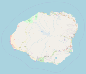
English:
Location map for Kauai, exported from OpenStreetMap (standard layer)
|
| Date | |
| Source | OpenStreetMap |
| Author | OSM contributors |
Licensing
| Description |
This map of Kauai was created from
OpenStreetMap
project data, collected by the community.
This map may be incomplete, and may contain errors. Don't rely solely on it for navigation.
|
|||||||||
| Date | (see file history) | |||||||||
| Source | openstreetmap.org | |||||||||
| Creator |
OpenStreetMap contributors
|
|||||||||
|
Permission
( Reusing this file ) |
OpenStreetMap data and maps are licensed under the
Creative Commons
Attribution-ShareAlike 2.0 license (CC-BY-SA 2.0).
This file is licensed under the
Creative Commons
Attribution-Share Alike 2.0 Generic
license.
|
|||||||||
| Geotemporal data | ||||||||||
| Bounding box |
|
|||||||||
| Georeferencing | If inappropriate please set warp_status = skip to hide. | |||||||||