Map_Battle_of_Stalingrad-en.svg

Size of this PNG preview of this SVG file:
564 × 600 pixels
.
Other resolutions:
226 × 240 pixels
|
452 × 480 pixels
|
722 × 768 pixels
|
963 × 1,024 pixels
|
1,927 × 2,048 pixels
|
1,699 × 1,806 pixels
.
| Description |
English:
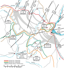
The Battle of Stalingrad (1942-1943)
|
||
| Date | |||
| Source |
This is basically the same thing as
Image:Battle of Stalingrad.png
, but in SVG format to facilitate editing. This file was
Vectorization:
iMeowbot
~. It is a recreation of the map at
http://www-cgsc.army.mil/carl/resources/csi/Sasso/Images/Stalin.gif
[
dead link
]
(
Wayback Machine snapshot (10 June 2007)
) For the original image, "Information presented on the CGSC web site is considered public information and may be distributed or copied. Use of appropriate byline/photo/image credits is requested."
http://www-cgsc.army.mil/notice.asp
[
dead link
]
(
Wayback Machine snapshot (27 September 2008)
)
|
||
| Author | iMeowbot | ||
|
Permission
( Reusing this file ) |
|
||
| Other versions |
Derivative works of this file:
[
]
|
||
| SVG development |


| Annotations | This image is annotated: View the annotations at Commons |