Map_Presenting_the_Discoveries_of_Russian_Navigators_in_the_Pacific_Ocean,_as_Well_as_Those_of_Captain_Cook_WDL127.png

Size of this preview:
800 × 557 pixels
.
Other resolutions:
320 × 223 pixels
|
640 × 446 pixels
|
1,024 × 713 pixels
|
1,280 × 891 pixels
|
1,471 × 1,024 pixels
.
Summary
| Author |
Русский:
Вильбрехт, Александр
Français :
Wilbrecht, Alexander
English:
Wilbrecht, Alexander
中文:
威尔伯特, 亚历山大
Português:
Wilbrecht, Alexander
العربية:
ويلبرخت, أليكسندر
Español:
Wilbrecht, Alexander
|
| Title |
Русский:
Карта географических открытий русских мореплавателей, исследователей Тихого океана, и открытий капитана Кука
Français :
Carte représentant les découvertes des navigateurs russes dans l'Océan Pacifique, ainsi que celles du Capitaine Cook
English:
Map Presenting the Discoveries of Russian Navigators in the Pacific Ocean, as Well as Those of Captain Cook
中文:
介绍俄国航海家在太平洋上的发现以及船长库克的地图
Português:
Mapa Apresentando as Descobertas dos Navegadores Russos no Oceano Pacífico, bem como as do Capitão Cook
العربية:
خريطة تعرض اكتشافات الملاحين الروس في المحيط الهادي، بالإضافة إلى اكتشافات الكابتن كوك
Español:
Mapa que presenta los descubrimientos de navegantes rusos en el Océano Pacífico así como aquellos del Capitán Cook
|
| Description |
Русский:
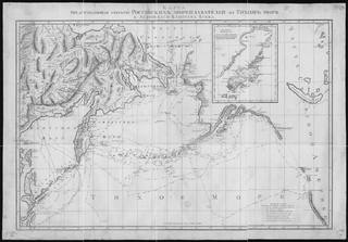
На этой карте 1787 года показаны путешествия крупнейших русских исследователей северной части Тихого океана: Беринга, Чирикова, Креницина, Шпанберга, Уолтона, Шельтинга и Петушкова. Показано также путешествие английского исследователя Джеймса Кука в 1778-1779 годах. Маршруты путешествий подробно обозначены: передвижение кораблей указано с точностью до суток. Среди прочих подробностей карты - административные границы, населенные пункты, чукотские поселения и участки непроходимых льдов. На карте-вкладке изображен остров Кодьяк на Аляске, обозначенный здесь под русским названием Кыктак.
Географические открытия; Открытия и исследования; Тихий океан
Français :
Cette carte de 1787 montre les itinéraires suivis par les principaux explorateurs russes dans le Pacifique Nord : Bering, Chirikov, Krenitsyn, Shpanberg, Walton, Shel'ting, et Petushkov. Elle montre aussi le parcours suivi par le capitaine britannique James Cook entre 1778 et 1779. L'itinéraire de chaque voyage est représenté dans ses moindres détails, avec un traçage au jour le jour des positions des navires. D'autres détails de la carte incluent les frontières administratives, les centres de population, les habitations des Chukchis et les barrières de glace. La carte en cartouche représente l'île de Kodiak, en Alaska, identifiée ici par son nom russe de Kykhtak.
Découvertes en géographie; Découverte et exploration; Océan Pacifique
English:
This 1787 map shows the voyages of the leading Russian explorers of the North Pacific: Bering, Chirikov, Krenitsyn, Shpanberg, Walton, Shel'ting, and Petushkov. It also shows the 1778-79 voyage of British Captain James Cook. The route of each voyage is depicted in great detail, with ship locations plotted by the day. Other details on the map include administrative borders, population centers, Chukchi dwellings, and impassable ice. The inset map is of Kodiak Island, Alaska, denoted here by its Russian name of Kykhtak.
Discoveries in geography; Discovery and exploration; Pacific Ocean
中文:
这幅于 1787 年绘制的地图描述了包括白令、奇里科夫、克雷尼特斯恩、史潘伯格、沃顿、希尔汀以及彼图什库瓦在内的俄罗斯探险先行者们在北太平洋的航程。 该地图还描述了英国船长詹姆斯·库克在 1778-79 年间的航程。 绘图人对每条航程的路线都做了详细的描述,还标出了当天船舶位置。 该地图上的其他细节还包括行政边界、人口中心、楚克其人住宅以及无法通行的结冰区。 地图插页为阿拉斯加的科迪亚克岛,此处标注着其俄语名称“Kykhtak“。
地理发现; 发现与探索; 太平洋
Português:
Este mapa de 1787 mostra as viagens dos exploradores líderes Russos do Pacífico Norte: Bering, Chirikov, Krenitsyn, Shpanberg,Walton, Shel'ting e Petushkov. Exibe também a viagem de 1778-79 do Capitão Britânico James Cook. O percurso de cada viagem é descrita em pormenor, com os navios locais plotados pelo dia. Outros detalhes sobre o mapa incluem as fronteiras administrativas, centros populacionais, habitações Chukchi, e intransitáveis gelo. O mapa inserido é da Ilha de Kodiak, Alasca, registrado aqui pelo seu nome Russo Kykhtak.
Descobertas de geografia; Descoberta e exploração; Oceano Pacífico
العربية:
هذا الخريطة تعود إلى 1787 وتظهر رحلات رواد المستكشفين الروس في شمال المحيط الهادئ: بيرنج وتشيريكوف وكرينيتسين وشبانبرج ووالتون وشيلتنج وبيتوشكوف. كذلك تبين رحلة الكابتن البريطاني جيمس كوك في 1778-79. إن مسار كل رحلة مصور بشكل مفصل وموقع كل سفينة مخطط بيانيا تبعا لليوم.
تشمل التفاصيل الأخرى على الخريطة الحدود الإدارية ومراكز السكان ومساكن التشوكتشى والجليد الذي لايمكن عبوره. الخريطة المدرجة هي خريطة جزيرة كودياك في ألاسكا والمشار إليها هنا باسمها الروسي كيخاتاك. الاكتشافات في الجغرافيا; الاكتشاف والاستكشاف; المحيط الهادئ
Español:
Este mapa de 1787 muestra los viajes de los primeros exploradores rusos al Pacífico Norte: Bering, Chirikov, Krenitsyn, Shpanberg, Walton, Shel'ting y Petushkov. También se muestra el viaje de 1778-79 del Capitán británico James Cook. La ruta de cada viaje se representa en gran detalle, con ubicaciones del buque trazadas por día. Otros detalles en el mapa son las fronteras administrativas, los centros de población, viviendas Chukchi y el intransitable hielo. El mapa en recuadro es la isla Kodiak, Alaska, que aparece aquí con su nombre ruso de Kykhtak.
Descubrimientos en geografía; Descubrimiento y exploración; Océano Pacífico |
| Date | 1787 |
| Medium |
Русский:
Карты
Français :
Cartes
English:
Maps
中文:
地图
Português:
Mapas
العربية:
خرائط
Español:
Mapas
|
| Dimensions |
English:
1 map 52 x 80 ; 63 x 89 ; (65 x 98)
|
| Collection |
Русский:
Российская национальная библиотека
Français :
Bibliothèque nationale de Russie
English:
National Library of Russia
中文:
俄罗斯国家图书馆
Português:
Biblioteca Nacional da Rússia
العربية:
مكتبة روسيا الوطنية
Español:
Biblioteca Nacional de Rusia
|
| Place of creation |
Русский:
Чукотка
Français :
Tchoukotka
English:
Chukotka
中文:
楚科奇
Português:
Chukotka
العربية:
تشوكوتكا
Español:
Chukotka
|
| Notes |
Original language title: Karta Predstavliaiushchaia Otkrytiia Rossiiskikh Moreplavatelei na Tikhom Okeane i Angliiskogo Kapitana Kukka
Русский:
Масштаб 1:2 520 000
Français :
Echelle 1:2 520 000
English:
Scale 1:2,520,000
中文:
比例尺:1:2,520,000
Português:
Escala 1:2.520.000
العربية:
مقياس 1:2،520،000
Español:
Escala 1:2.520.000
|
| References | http://hdl.loc.gov/loc.wdl/rusprnb.127 |
| Source/Photographer |
|
Licensing
|
This is a faithful photographic reproduction of a two-dimensional,
public domain
work of art. The work of art itself is in the public domain for the following reason:
The official position taken by the Wikimedia Foundation is that "
faithful reproductions of two-dimensional public domain works of art are public domain
".
This photographic reproduction is therefore also considered to be in the public domain in the United States. In other jurisdictions, re-use of this content may be restricted; see Reuse of PD-Art photographs for details. |
||||