Map_of_Alpine_Glaciations.png

Size of this preview:
800 × 512 pixels
.
Other resolutions:
320 × 205 pixels
|
640 × 410 pixels
|
1,026 × 657 pixels
.

|
This
geology
image could be re-created
using
vector graphics
as an
SVG
file
. This has several advantages; see
Commons:Media for cleanup
for more information. If an SVG form of this image is available, please upload it and afterwards replace this template with
{{

vector version available

|

new image name

}}
.
It is recommended to name the SVG file “Map of Alpine Glaciations.svg”—then the template Vector version available (or Vva ) does not need the new image name parameter. |
| Description |
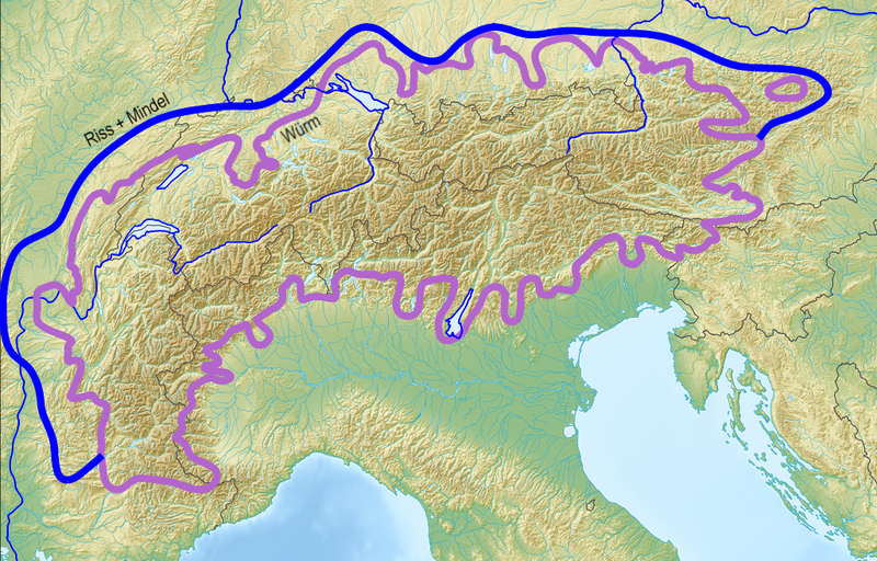
Deutsch:
Ungefähre Ausdehnung der Vereisungen in den
Alpen
English:
Approximate extent of alpine glaciations
|
| Date | (UTC) |
| Source |
|
| Author |
|
|
|
This is a
retouched picture
, which means that it has been digitally altered from its original version. Modifications:
Limits of alpine ice sheets, cropped black border
. The original can be viewed here:
Alps location map.png
:
|
I, the copyright holder of this work, hereby publish it under the following licenses:
|
|
This file is licensed under the Creative Commons Attribution-Share Alike 3.0 Unported license. | |
|
||
| This licensing tag was added to this file as part of the GFDL licensing update . |

|
Permission is granted to copy, distribute and/or modify this document under the terms of the GNU Free Documentation License , Version 1.2 or any later version published by the Free Software Foundation ; with no Invariant Sections, no Front-Cover Texts, and no Back-Cover Texts. A copy of the license is included in the section entitled GNU Free Documentation License . |
You may select the license of your choice.
|
|
The map has been created with the
Generic Mapping Tools
:
https://www.generic-mapping-tools.org/
using one or more of these
public-domain
datasets for the relief:
|
|
|
Permission is granted to copy, distribute and/or modify this document under the terms of the GNU Free Documentation License , Version 1.2 or any later version published by the Free Software Foundation ; with no Invariant Sections, no Front-Cover Texts, and no Back-Cover Texts. A copy of the license is included in the section entitled GNU Free Documentation License . |
Original upload log
This image is a derivative work of the following images:
-
File:Alps_location_map.png
licensed with Cc-by-sa-3.0-migrated, GFDL-GMT
- 2009-02-20T12:58:57Z Lencer 2000x1381 (4957657 Bytes) {{Information |Description= {{de|Positionskarte der [[:de:Alpen|Alpen]]}} Quadratische Plattkarte. Geographische Begrenzung der Karte: * N: 48.5 ° N * S: 42.75 ° N * W: 4.5 ° O * O: 17 ° O {{en|Location map of the
Uploaded with derivativeFX