Map_of_Spis_pawned_towns.jpg

Size of this preview:
424 × 599 pixels
.
Other resolutions:
170 × 240 pixels
|
339 × 480 pixels
|
543 × 768 pixels
|
724 × 1,024 pixels
|
2,339 × 3,307 pixels
.
Summary

|
This
map
image could be re-created
using
vector graphics
as an
SVG
file
. This has several advantages; see
Commons:Media for cleanup
for more information. If an SVG form of this image is available, please upload it and afterwards replace this template with
{{

vector version available

|

new image name

}}
.
It is recommended to name the SVG file “Map of Spis pawned towns.svg”—then the template Vector version available (or Vva ) does not need the new image name parameter. |


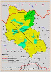
| Description | Map of Spis pawned towns and villages to Poland by Hungarian king Sigismund, Holy Roman Emperor; (1412-1772) |
| Date | |
| Source | Own work |
| Author | Kristo |
| Other versions | older version deleted |
Licensing
| I, Kristián Slimák, the author of this work, hereby publish it under the following licenses: | ||||
This file is licensed under the
Creative Commons
Attribution-Share Alike 2.5 Generic
license.
To provide attribution, credit the author as Kristián Slimák . You may select the license of your choice. |
