Map_of_the_Territorial_Waters_of_the_Pacific_Ocean.png

Size of this preview:
800 × 438 pixels
.
Other resolutions:
320 × 175 pixels
|
640 × 350 pixels
|
1,024 × 560 pixels
|
1,280 × 700 pixels
|
3,067 × 1,678 pixels
.

|
This
map
image could be re-created
using
vector graphics
as an
SVG
file
. This has several advantages; see
Commons:Media for cleanup
for more information. If an SVG form of this image is available, please upload it and afterwards replace this template with
{{

vector version available

|

new image name

}}
.
It is recommended to name the SVG file “Map of the Exclusive Economic Zones of the Pacific Ocean.svg”—then the template Vector version available (or Vva ) does not need the new image name parameter. |
Summary
| Description |
Deutsch:
Ausschließliche Wirtschaftszonen (EEZ) im Pazifischen Ozean
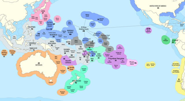
English:
Exclusive Economic Zones (EEZ) of the Pacific Ocean
Français :
Zones économiques exclusives (ZEE) de l'océan Pacifique
Euskara:
Ozeano Bareko Ekonomia-eremu esklusiboak (EEE)
|
| Date | see file history |
| Source | Own work using: this map by B1mbo |
| Author | Maximilian Dörrbecker ( Chumwa ) |
|
Permission
( Reusing this file ) |
I, the copyright holder of this work, hereby publish it under the following license:
This file is licensed under the
Creative Commons
Attribution-Share Alike 2.5 Generic
license.
Sie dürfen das Bild zu den folgenden Bedingungen nutzen:
|
| Other versions |
|
.png)


