Medieval_Livonia_1260.svg

Size of this PNG preview of this SVG file:
554 × 600 pixels
.
Other resolutions:
222 × 240 pixels
|
443 × 480 pixels
|
709 × 768 pixels
|
946 × 1,024 pixels
|
1,891 × 2,048 pixels
|
955 × 1,034 pixels
.
Summary
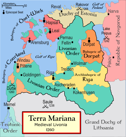
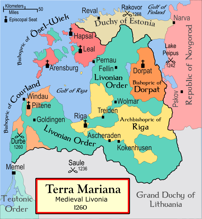
| Description | A political map of the Medieval Livonia , circa 1260, along with surrounding areas |
| Date | 13 November 2008 (original upload date) |
| Source | No machine-readable source provided. Own work assumed (based on copyright claims). |
| Author | No machine-readable author provided. Termer assumed (based on copyright claims). |
| Other versions | Magyar |
Foreign language versions
References
- Turnbull, Stephen (2004) Crusader Castles of the Teutonic Knights (2) , Osprey Publishing ISBN 1841767123
- Bjorklund, Oddvar; Holmboe, Haakon; Rohr, Anders (1970) Historical Atlas of the World , Barnes & Noble, NY, SBN: 389-00253-4.
- This 500 year old map of Lithuania, from UNESCO
- WHKMLA Historical Atlas - Estonia , accessed on November 2, 2006.
Licensing
I, the copyright holder of this work, hereby publish it under the following license:

|
Permission is granted to copy, distribute and/or modify this document under the terms of the GNU Free Documentation License , Version 1.2 or any later version published by the Free Software Foundation ; with no Invariant Sections, no Front-Cover Texts, and no Back-Cover Texts. A copy of the license is included in the section entitled GNU Free Documentation License . |
|
|
This file is licensed under the Creative Commons Attribution-Share Alike 3.0 Unported license. | |
|
||
| This licensing tag was added to this file as part of the GFDL licensing update . |