Melbourne_Skyline_from_Rialto_Crop_-_Nov_2008.jpg

Size of this preview:
799 × 257 pixels
.
Other resolutions:
320 × 103 pixels
|
640 × 206 pixels
|
1,024 × 330 pixels
|
1,280 × 412 pixels
|
2,560 × 824 pixels
|
8,527 × 2,744 pixels
.
|

Summary
| Description |
English:
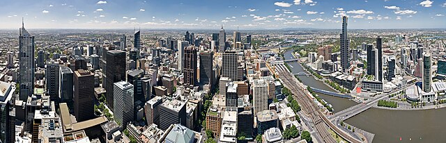
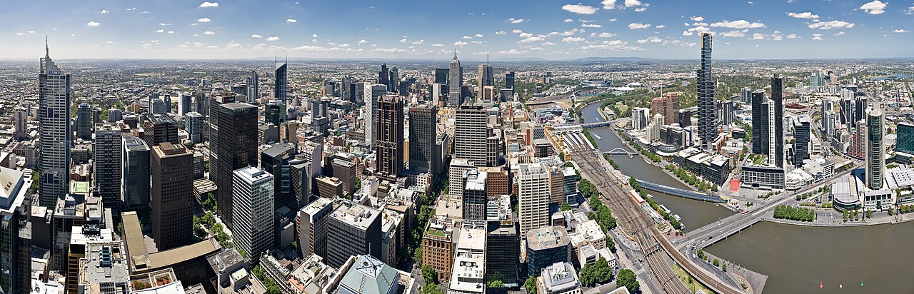
The Melbourne skyline as viewed from the Rialto Observatory on Collins St. This panorama spans facing north (left side) east (centre) to south (right side). Taken as a 2 x 5 segment panorama by myself with a Canon 5D and 17-40mm f/4L lens. This image is a crop of the original as per below.
Deutsch:
Der Melbourne Skyline von der Rialto-Aussichtsplattform auf Collins Street angesehen. 180-Grad-Panoramablick erstreckt sich nach Norden (links), nach Osten (Mitte) und nach Süden (rechts) aus 10 Bildern (zwei Reihen von 5) unter Verwendung einer Canon 5D mit einem 17-40mm f/4L Linse.
Français :
La ville de Melbourne vue depuis le sommet de la tour Rialto sur Collins Street. Vue panoramique à 180 degrés centrée sur l'est (Le nord est à gauche, le sud à droite de la photo) réalisé à partir de 10 clichés (en deux rangs de 5) obtenus à l'aide d'un appareil Canon 5D équipé d'un objectif 17-40mm f/4L.
Türkçe:
Collins Street üzerinde bulunan Rialto Observatory'den Melbourne'nın panoramik manzarası. Yarra Nehri'nin kuzey kıyısında bulunan Melbourne'nın merkezi ticaret bölgesi, Flinders Street İstasyonu çevresi ve güney kıyısında bulunan South Bank görünmektedir. (25 Kasım 2008)
|
| Date | |
| Source | Own work |
| Author | Diliff |
|
Permission
( Reusing this file ) |
Summary:
|
| Other versions |


|
| Camera location |
|
View this and other nearby images on: OpenStreetMap |
|
|---|
Licensing
I, the copyright holder of this work, hereby publish it under the following licenses:
This file is licensed under the
Creative Commons
Attribution-Share Alike 3.0 Unported
license.
-
You are free:
- to share – to copy, distribute and transmit the work
- to remix – to adapt the work
-
Under the following conditions:
- attribution – You must give appropriate credit, provide a link to the license, and indicate if changes were made. You may do so in any reasonable manner, but not in any way that suggests the licensor endorses you or your use.
- share alike – If you remix, transform, or build upon the material, you must distribute your contributions under the same or compatible license as the original.

|
Permission is granted to copy, distribute and/or modify this document under the terms of the GNU Free Documentation License , Version 1.2 or any later version published by the Free Software Foundation ; with no Invariant Sections, no Front-Cover Texts, and no Back-Cover Texts. A copy of the license is included in the section entitled GNU Free Documentation License . |
You may select the license of your choice.
|
|
This image has been assessed using the
Quality image guidelines
and is considered a
Quality image
.
|