Melbourne_at_night_from_the_International_Space_Station.jpg

Size of this preview:
800 × 532 pixels
.
Other resolutions:
320 × 213 pixels
|
640 × 426 pixels
|
1,024 × 681 pixels
|
1,280 × 852 pixels
|
2,128 × 1,416 pixels
.
Summary
| Description |
English:
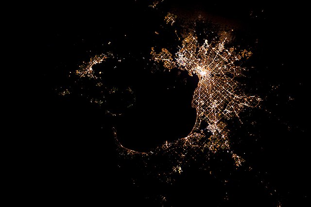
The city of
Melbourne, Victoria, Australia
seen from the International Space Station at night reveals its young history. Unlike the winding streets of older cities, Melbourne’s streetlights follow a more planned grid system. Established in 1835 around the natural bay of Port Phillip, Melbourne is the capital of the state of Victoria in Australia.
The Nepean highway going south to Frankston circles the bay but stops at the Bass Strait. To the left is Geelong , 75 km south-west of Melbourne. The brightly-lit Point Henry is visible as a yellow triangle reaching out into Corio Bay. This image was taken by an astronaut on the International Space Station with Nightpod in 2012. The Nightpod camera-stand tracks the movement of Earth passing under the Station at 28 800 km/h, keeping any target fixed in the middle of the viewfinder. Standard cameras fixed to Nightpod can use longer exposure times so that astronauts can take sharper pictures of cities at night. |
| Date | Taken on 20 March 2012, 13:34:39 |
| Source | https://www.esa.int/ESA_Multimedia/Images/2012/04/Melbourne |
| Author | European Space Agency |
Licensing
|
|
This file is made available under the Creative Commons CC0 1.0 Universal Public Domain Dedication . |
|
The person who associated a work with this deed has dedicated the work to the
public domain
by waiving all of their rights to the work worldwide under copyright law, including all related and neighboring rights, to the extent allowed by law. You can copy, modify, distribute and perform the work, even for commercial purposes, all without asking permission.
|