Metropolitan_and_non-metropolitan_counties_of_England_2009_(numbered).svg

Size of this PNG preview of this SVG file:
494 × 600 pixels
.
Other resolutions:
198 × 240 pixels
|
395 × 480 pixels
|
633 × 768 pixels
|
843 × 1,024 pixels
|
1,687 × 2,048 pixels
|
1,108 × 1,345 pixels
.
Summary
| Description |
English:
minor improvement to
File:English_metropolitan_and_non-metropolitan_counties_2009_(numbered).svg
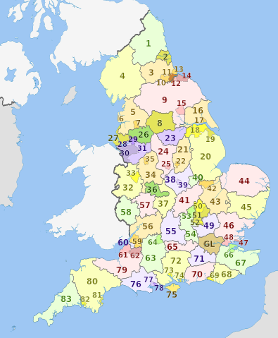
Map of the metropolitan and non-metropolitan counties of England from 2009, excluding the City of London. Equirectangular map projection on WGS 84 datum, with N/S stretched 170% Geographic limits:
|
| Date | |
| Source |
This file was derived from:
English metropolitan and non-metropolitan counties 2009 (numbered).svg
:
.svg)
|
| Author |
|
Licensing
This file is licensed under the
Creative Commons
Attribution-Share Alike 4.0 International
license.
Attribution:
Ujongbakuto, Dr Greg and Nilfanion. Contains Ordnance Survey data © Crown copyright and database right 2010.
-
You are free:
- to share – to copy, distribute and transmit the work
- to remix – to adapt the work
-
Under the following conditions:
- attribution – You must give appropriate credit, provide a link to the license, and indicate if changes were made. You may do so in any reasonable manner, but not in any way that suggests the licensor endorses you or your use.
- share alike – If you remix, transform, or build upon the material, you must distribute your contributions under the same or compatible license as the original.