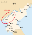
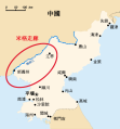
MiG_Alley_Map_(en).svg

Size of this PNG preview of this SVG file:
557 × 599 pixels
.
Other resolutions:
223 × 240 pixels
|
446 × 480 pixels
|
714 × 768 pixels
|
952 × 1,024 pixels
|
1,903 × 2,048 pixels
|
696 × 749 pixels
.
Summary
| Description MiG Alley Map (en).svg |
English:
The area called "MiG Alley" during the Korean War (1950-53) on the Chinese-North Korean border. See also:
File:Usaf-korea-map.jpg
(US Army)
|
|||
|
Typeface
InfoField
|
||||
| Date | ||||
| Source |
This file was derived from:
MiG Alley Map.JPG
|
|||
| Author |
|
|||
| Other versions |
|
|||
|
SVG development
InfoField
|
|
Licensing
| Public domain Public domain false false |
|
|
I, the copyright holder of this work, release this work into the
public domain
. This applies worldwide.
In some countries this may not be legally possible; if so: I grant anyone the right to use this work for any purpose , without any conditions, unless such conditions are required by law. |
Captions
Add a one-line explanation of what this file represents


