Minard's_Map_(vectorized).svg

Size of this PNG preview of this SVG file:
800 × 386 pixels
.
Other resolutions:
320 × 154 pixels
|
640 × 308 pixels
|
1,024 × 494 pixels
|
1,280 × 617 pixels
|
2,560 × 1,234 pixels
|
2,023 × 975 pixels
.
Summary
| Description |
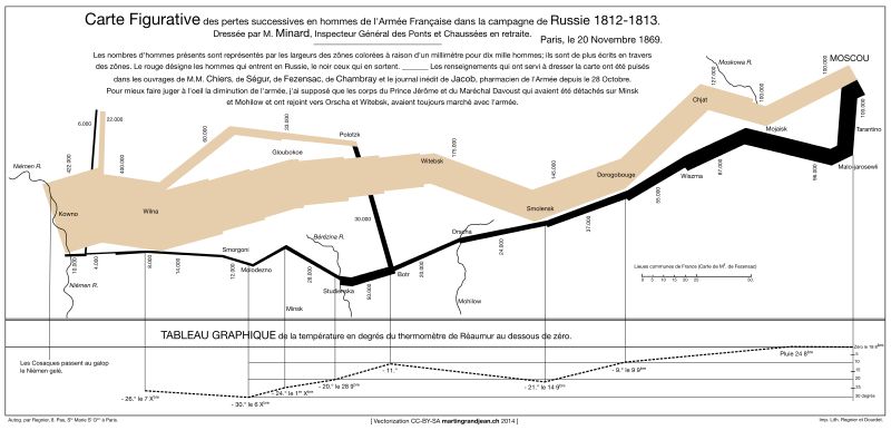
Français :
Carte vectorisée de
Charles Joseph Minard
(1869) montrant le trajet et l'effectif des troupes napoléoniennes lors de la campagne de Russie (1812-1813) ainsi que la température lors de la retraite.
À propos
English:
Charles Joseph Minard
's vectorized map (1869) displaying the movements and the number of Napoleonic troops during the Russian campaign (1812-1813), as well as the temperature on the return path.
About
|
| Date | |
| Source | Grandjean Martin, Historical Data Visualization: Minard’s map vectorized and revisited , 2014, online: http://www.martingrandjean.ch/historical-data-visualization-minard-map/ |
| Author | Martin Grandjean |

|
The file size of this
SVG image
may be abnormally large because most or all of its text has been converted to
paths
rather than using the more conventional
<text>
element. Unless rendering the text of the SVG file produces an image with text that is incurably unreadable due to
technical limitations
, it is highly recommended to change the paths back to text. Doing so will ease the process of localizing this image to other languages and is likely to
reduce the file size
in a significant scale.
Other SVGs containing path-based text can be found at
Category:Path text SVG
. For more information, see
SVG: Fonts
and
Preparing images for upload: Text
.
|

|
Licensing
I, the copyright holder of this work, hereby publish it under the following license:
This file is licensed under the
Creative Commons
Attribution-Share Alike 3.0 Unported
license.
-
You are free:
- to share – to copy, distribute and transmit the work
- to remix – to adapt the work
-
Under the following conditions:
- attribution – You must give appropriate credit, provide a link to the license, and indicate if changes were made. You may do so in any reasonable manner, but not in any way that suggests the licensor endorses you or your use.
- share alike – If you remix, transform, or build upon the material, you must distribute your contributions under the same or compatible license as the original.