Morocco_Protectorate.svg


Summary

Description
English: 
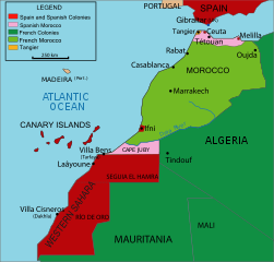
Vectorised map about the French and Spanish protectorate on Morocco in 1912 - own work inspired from Jean Sellier, Atlas des peuples d'Afrique, p. 84.
Français : Protectorat marocain
Español: Protectorado marroquí
A PNG french version is available
Source Image:Maroc sans cadre.svg
Author Cradel
Permission
( Reusing this file )
I, the copyright holder of this work, hereby publish it under the following licenses:
GNU head Permission is granted to copy, distribute and/or modify this document under the terms of the GNU Free Documentation License , Version 1.2 or any later version published by the Free Software Foundation ; with no Invariant Sections, no Front-Cover Texts, and no Back-Cover Texts. A copy of the license is included in the section entitled GNU Free Documentation License .
w:en:Creative Commons
attribution share alike
This file is licensed under the Creative Commons Attribution-Share Alike 3.0 Unported license.
You are free:
  • to share – to copy, distribute and transmit the work
  • to remix – to adapt the work
Under the following conditions:
  • attribution – You must give appropriate credit, provide a link to the license, and indicate if changes were made. You may do so in any reasonable manner, but not in any way that suggests the licensor endorses you or your use.
  • share alike – If you remix, transform, or build upon the material, you must distribute your contributions under the same or compatible license as the original.
This licensing tag was added to this file as part of the GFDL licensing update .
w:en:Creative Commons
attribution share alike
This file is licensed under the Creative Commons Attribution-Share Alike 2.5 Generic , 2.0 Generic and 1.0 Generic license.
You are free:
  • to share – to copy, distribute and transmit the work
  • to remix – to adapt the work
Under the following conditions:
  • attribution – You must give appropriate credit, provide a link to the license, and indicate if changes were made. You may do so in any reasonable manner, but not in any way that suggests the licensor endorses you or your use.
  • share alike – If you remix, transform, or build upon the material, you must distribute your contributions under the same or compatible license as the original.
You may select the license of your choice.
Other versions
SVG development
InfoField
The source code of this SVG is invalid due to 238 errors.
This W3C- invalid map was created with Adobe Illustrator ,
and with Inkscape.
This bad Adobe SVG map is very large because its creator kept the superfluous Adobe PGF or other CDATA garbage
.
The file size of this SVG map may be irrationally large because its text has been converted to paths inhibiting translations.

Captions

Add a one-line explanation of what this file represents

Items portrayed in this file

depicts

image/svg+xml