Muromian-map.png

Size of this preview:
588 × 600 pixels
.
Other resolutions:
235 × 240 pixels
|
610 × 622 pixels
.

|
File:Finno-ugrian-map.svg
is a vector version of this file. It should be used in place of this PNG file when not inferior.
File:Muromian-map.png →
File:Finno-ugrian-map.svg
For more information, see
Help:SVG
.
|

|
Summary
| Description |
English:
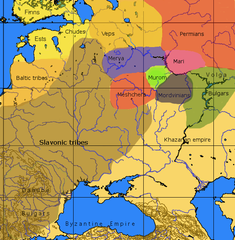
An approximate ethno-linguistic map of Kievan Rus' in the 9th century: Five Volga Finnic groups of the Merya, Mari, Muromians, Meshchera and Mordvins are shown as surrounded by the Slavs to the west; the three Finnic groups of the Veps, Ests and Chuds, and Indo-European Balts to the northwest; the Permians to the northeast the (Turkic) Bulghars and Khazars to the southeast and south.
|
| Source | File:Finno-ugrian-map.svg states that it is based on Рябинин Е. А. Финно-угорские племена в составе Древней Руси . |
| Author | Wiglaf . |
Licensing

|
Permission is granted to copy, distribute and/or modify this document under the terms of the GNU Free Documentation License , Version 1.2 or any later version published by the Free Software Foundation ; with no Invariant Sections, no Front-Cover Texts, and no Back-Cover Texts. A copy of the license is included in the section entitled GNU Free Documentation License . |
|
|
This file is licensed under the Creative Commons Attribution-Share Alike 3.0 Unported license. | |
|
||
| This licensing tag was added to this file as part of the GFDL licensing update . |
Other versions
-
 Español
 -
 Italiano
 -
 suomi
suomi


