Muscovy_1390_1525.png
No higher resolution available.
| Description |
English:
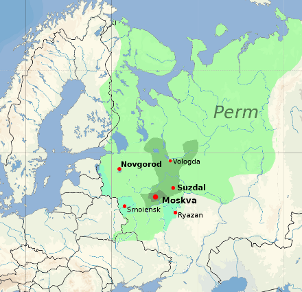
Territorial expansion of the Grand Duchy of Moscow, 1300–1547
Core territory of Muscovy, 1300
Territory of Vladimir-Suzdal, acquired by Muscovy by 1390
Territory acquired by 1505 (Ivan III)
Territory acquired by 1533 (Vasili III)
Modern national borders are shown for orientation.
|
|||
| Date | ||||
| Source |
blank map: File:Europe location POR.png . Territorial boundaries based on File:Moscow1500.png , File:Kievan-rus-1015-1113-(en).png , File:Muscovy 1300-1462.png . See also File:Russia 1533-1896.gif . See talkpage for discussion of the sources used. Information on historical territory relies on maps uploaded by ru:Участник:Koryakov Yuri (2008). |
|||
| Author | Dbachmann | |||
|
Permission
( Reusing this file ) |
derivative work based on the blank map by David Liuzzo .
|

.png)

|
This
historical map
image could be re-created
using
vector graphics
as an
SVG
file
. This has several advantages; see
Commons:Media for cleanup
for more information. If an SVG form of this image is available, please upload it and afterwards replace this template with
{{

vector version available

|

new image name

}}
.
It is recommended to name the SVG file “Muscovy 1390 1525.svg”—then the template Vector version available (or Vva ) does not need the new image name parameter. |