Nazi_Germany.svg

Size of this PNG preview of this SVG file:
773 × 600 pixels
.
Other resolutions:
309 × 240 pixels
|
619 × 480 pixels
|
990 × 768 pixels
|
1,280 × 993 pixels
|
2,560 × 1,986 pixels
|
1,419 × 1,101 pixels
.

| Description |
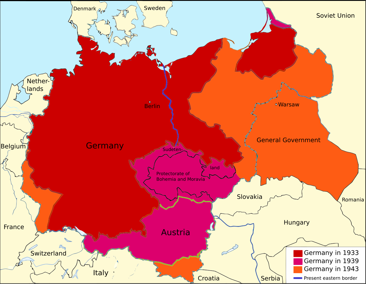
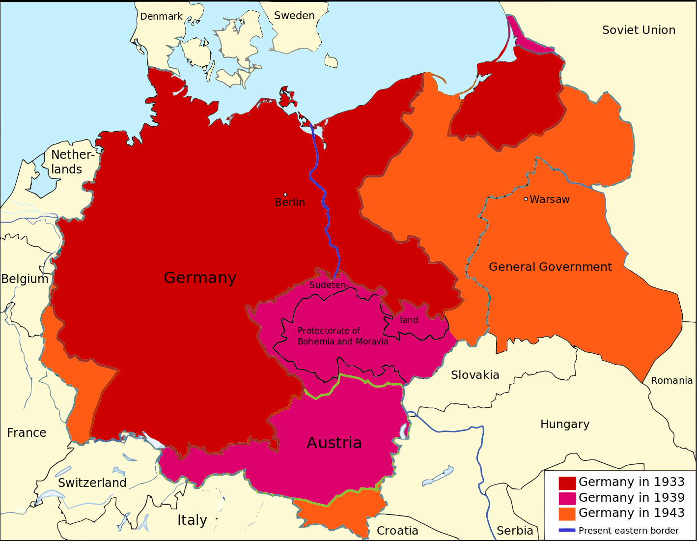
English:
An overview map of
Nazi Germany
to 1943.
Nederlands:
Een overzichtskaart van Nazi-Duitsland in t/m 1943.
|
| Date | (UTC) |
| Source | |
| Author |
|
|
This
vector image
was created with another SVG tool.
|
|
|
This is a
retouched picture
, which means that it has been digitally altered from its original version. Modifications:
Converted to SVG
. The original can be viewed here:
Nazi Germany.png
:
|

|
This SVG file contains embedded text that can be translated into your language, using any capable SVG editor, text editor or the SVG Translate tool . For more information see: About translating SVG files . |
I, the copyright holder of this work, hereby publish it under the following licenses:
|
|
This file is licensed under the Creative Commons Attribution-Share Alike 3.0 Unported license. | |
|
||
| This licensing tag was added to this file as part of the GFDL licensing update . |

|
Permission is granted to copy, distribute and/or modify this document under the terms of the GNU Free Documentation License , Version 1.2 or any later version published by the Free Software Foundation ; with no Invariant Sections, no Front-Cover Texts, and no Back-Cover Texts. A copy of the license is included in the section entitled GNU Free Documentation License . |
You may select the license of your choice.
Original upload log
This image is a derivative work of the following images:
-
File:Nazi_Germany.png
licensed with Cc-by-sa-3.0-migrated, GFDL
- 2009-06-06T23:35:17Z MaggotMaster 1200x932 (269038 Bytes) Reverted to version as of 22:18, 21 May 2009
- 2009-06-04T11:57:51Z Fz22 1200x932 (239491 Bytes) {{Information |Description= |Source= |Date= |Author= |Permission= |other_versions= }}
- 2009-05-21T22:18:00Z Hohum 1200x932 (269038 Bytes) Reduced garish colour intensity.
- 2009-01-19T09:30:09Z Brianski 1200x932 (212419 Bytes) clean up the legend
- 2008-10-08T20:20:19Z File Upload Bot (Magnus Manske) 1200x932 (281968 Bytes) {{BotMoveToCommons|en.wikipedia}} {{Information |Description={{en|An overview map of Nazi Germany, based on another map ([[:en::Image:GDR.png]]) by [[:en::de:Benutzer:kgberger|kgberger]]. Placenames replaced with English one
Uploaded with derivativeFX