Netherlands-CIA_WFB_Map-10-10-10.png
No higher resolution available.
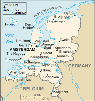
| Description | Map of the Netherlands |
| Date | (UTC) |
| Source | |
| Author |
|
|
|
This is a
retouched picture
, which means that it has been digitally altered from its original version. The original can be viewed here:
Netherlands-CIA WFB Map.png
:
|
|
|
This image is in the
public domain
because it contains materials that originally came from the United States
Central Intelligence Agency
's
World Factbook
.
|

|
Original upload log
This image is a derivative work of the following images:
- File:Netherlands-CIA_WFB_Map.png licensed with PD-USGov-CIA-WF
Uploaded with derivativeFX