New_Brunswick_topographic_map-fr.svg

Size of this PNG preview of this SVG file:
610 × 600 pixels
.
Other resolutions:
244 × 240 pixels
|
488 × 480 pixels
|
781 × 768 pixels
|
1,042 × 1,024 pixels
|
2,083 × 2,048 pixels
|
2,237 × 2,199 pixels
.
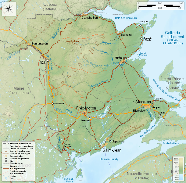
Summary
| Description |
English
:
General map of
New Brunswick
, Canada, with topographic bakground (embeded raster file). French version.
Equirectangular projection, WGS84 datum
Geographic limits of the map:
Français
:
Carte générale du
Nouveau-Brunswick
, Canada, avec un fond topographique (fichier matriciel incorporé). Version en français.
Projection équirectangulaire, système géodétique WGS84.
Limites géographiques de la carte :
|
||
| Date | |||
| Source |
Own work .
English
:
Français
:
|
||
| Author | Sémhur ( talk ) | ||
| Other versions | |||
|
Attribution
( required by the license ) |
© Sémhur / Wikimedia Commons / | ||
| SVG |
W3C-validity not checked.
|
||
| Graphic Lab |

| Camera location |
|
View this and other nearby images on: OpenStreetMap |
|
|---|
Licensing
I, the copyright holder of this work, hereby publish it under the following licenses:
|
|
Copyleft: This work of art is free; you can redistribute it and/or modify it according to terms of the Free Art License . You will find a specimen of this license on the Copyleft Attitude site as well as on other sites . |
This file is licensed under the
Creative Commons
Attribution-Share Alike
4.0 International
,
3.0 Unported
,
2.5 Generic
,
2.0 Generic
and
1.0 Generic
license.
-
You are free:
- to share – to copy, distribute and transmit the work
- to remix – to adapt the work
-
Under the following conditions:
- attribution – You must give appropriate credit, provide a link to the license, and indicate if changes were made. You may do so in any reasonable manner, but not in any way that suggests the licensor endorses you or your use.
- share alike – If you remix, transform, or build upon the material, you must distribute your contributions under the same or compatible license as the original.
You may select the license of your choice.