Newliston_House_-_geograph.org.uk_-_1306052.jpg
No higher resolution available.
|
This is a photo of
listed building
number
27578
.
|
Summary
| Description |
English:
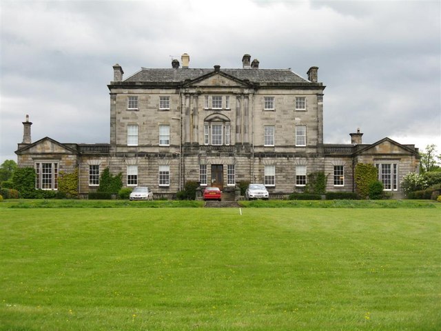
Newliston House A Robert Adam house, one of his last, completed in 1792 shortly after his death. The wings were added in 1845. It replaced an earlier house, of which there is no trace. A private home open, with the extensive grounds, on Garden Open Days.
|
| Date | |
| Source | From geograph.org.uk |
| Author | M J Richardson |
|
Attribution
( required by the license ) |
M J Richardson / Newliston House / |
| Camera location |
|
View this and other nearby images on: OpenStreetMap |
|
|---|
_heading:337.00&language=en)
| Object location |
|
View this and other nearby images on: OpenStreetMap |
|
|---|
_heading:337.00&language=en)
Licensing

|
This image was taken from the
Geograph project
collection. See
this photograph's page
on the Geograph website for the photographer's contact details. The copyright on this image is owned by
M J Richardson
and is licensed for reuse under the
Creative Commons
Attribution-ShareAlike 2.0 license.
|
This file is licensed under the
Creative Commons
Attribution-Share Alike 2.0 Generic
license.
Attribution:
M J Richardson
-
You are free:
- to share – to copy, distribute and transmit the work
- to remix – to adapt the work
-
Under the following conditions:
- attribution – You must give appropriate credit, provide a link to the license, and indicate if changes were made. You may do so in any reasonable manner, but not in any way that suggests the licensor endorses you or your use.
- share alike – If you remix, transform, or build upon the material, you must distribute your contributions under the same or compatible license as the original.