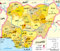
Nigeria_political.png

|
This
locator map
image could be re-created
using
vector graphics
as an
SVG
file
. This has several advantages; see
Commons:Media for cleanup
for more information. If an SVG form of this image is available, please upload it and afterwards replace this template with
{{

vector version available

|

new image name

}}
.
It is recommended to name the SVG file “Nigeria political.svg”—then the template Vector version available (or Vva ) does not need the new image name parameter. |
| Description Nigeria political.png |
English:
Political map of the 36 States of Nigeria (English)
Deutsch:
politische Karte Nigerias (Englisch)
|
| Date | adapted 27-03-2009 |
| Source | Self-adapted from de.wikipedia . Page is here |
| Author | Domenico-de-ga , translated and adapted by xandar |
|
Permission
( Reusing this file ) |
Released under the GNU Free Documentation License. |
| Other versions |
|
Licensing

|
Permission is granted to copy, distribute and/or modify this document under the terms of the GNU Free Documentation License , Version 1.2 or any later version published by the Free Software Foundation ; with no Invariant Sections, no Front-Cover Texts, and no Back-Cover Texts. A copy of the license is included in the section entitled GNU Free Documentation License . http://www.gnu.org/copyleft/fdl.html GFDL GNU Free Documentation License true true |
|
|
If this file is
eligible for relicensing
, it may also be used under the
Creative Commons Attribution-ShareAlike 3.0
license.
The relicensing status of this image needs to be manually reviewed by an experienced user.
You can help
.
العربيَّة | беларуская (тарашкевіца) | English | français | magyar | italiano | 日本語 | 한국어 | македонски | മലയാളം | sicilianu | українська | 中文 | +/− |
|
Captions
Add a one-line explanation of what this file represents
Máàpù Orílẹ̀-èdè Nàìjíríà pẹ̀lú àwọn Ìpínlẹ̀ mẹ́rìndínlógójì àti Olú-ìlú Abuja


