Non-Native_American_Nations_Control_over_N_America_1750-2008.gif
Size of this preview:
536 × 600 pixels
.
Other resolutions:
215 × 240 pixels
|
429 × 480 pixels
|
700 × 783 pixels
.
Summary
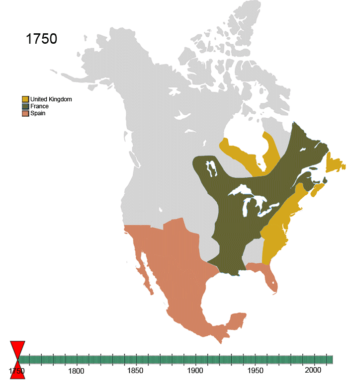
| Description | Non- Native-American Nation 's Control over North America circe 1750-2008 | |||
| Date | ||||
| Source | Own work | |||
| Author | Esemono | |||
|
Permission
( Reusing this file ) |
|
|||
| Other versions |
|


English:
Animated
Map of the history of North America
— from 1750 to 2008.
-
-
- Showing the changing control of colonial territories and independent nations, over 250 years in North America .
- NOTE: The declining—lost control of the Indigenous peoples of North America over their traditional territories and established homelands and cultural regions — is not considered in this euro-centric map.
-
| France |
|
||
| Present day Canada | |||
|---|---|---|---|
| Canada |
|
||
| Dominion of Newfoundland |
|
||
| France |
|
||
| Britain |
|
||
| Present day USA | |||
| United States of America |
|
||
| California Republic |
|
||
| Confederate States of America |
|
||
| France |
|
||
| Republic of Indian Stream | No flag | ||
| Republic of Texas |
|
||
| Republic of Vermont |
|
||
| Republic of West Florida |
|
||
| Russia |
|
||
| Spain |
|
||
| Britain |
|
||
| Present day Mexico | |||
| Federal Republic of Central America |
|
||
| Mexico |
|
||
| Spain |
|
||
| Republic of the Rio Grande |
|
||
| Yucatán |
|
||
For notes on the individual border changes see Territorial evolution of North America . To make your own animated image use the slides below:


See Also
-
 North America
 -
 Central America
 -
 Balkans
 -
 South America
 -
 Canada
 -
 United States
 -
 Mexico
 -
 Blank map


