Orogenic_wedge.jpg
No higher resolution available.
Summary
| Description |
English:
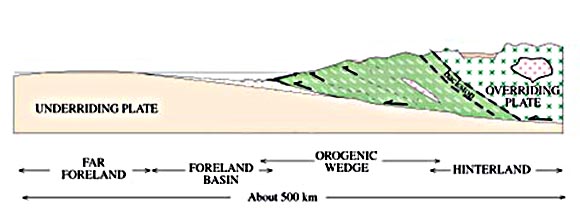
An illustration of the collision between two tectonic plates. One plate goes under the other, and the result is the buildup of a critical wedge of material. This orogenic wedge, or mountain-building wedge, maintains its slope by a stress balance between failures along the décollment, or main basal fault, and the faults inside the wedge.
|
| Date | |
| Source | U.S. Geological Survey Professional Paper 1624 - Online version 1.0: Migration of the Acadian Orogen and Foreland Basin Across the Northern Appalachians of Maine and Adjacent Areas: http://pubs.usgs.gov/pp/pp1624/ |
| Author | Dwight C. Bradley, Robert D. Tucker, Daniel R. Lux, Anita G. Harris, and D. Colin McGregor |

|
This
geology
image could be re-created
using
vector graphics
as an
SVG
file
. This has several advantages; see
Commons:Media for cleanup
for more information. If an SVG form of this image is available, please upload it and afterwards replace this template with
{{

vector version available

|

new image name

}}
.
It is recommended to name the SVG file “Orogenic wedge.svg”—then the template Vector version available (or Vva ) does not need the new image name parameter. |


Licensing
|
|
This image is in the
public domain
in the United States because it only contains materials that originally came from the
United States Geological Survey
, an agency of the
United States Department of the Interior
. For more information, see
the official USGS copyright policy
.
|
|