Ossetia01.png
Size of this preview:
391 × 599 pixels
.
Other resolutions:
156 × 240 pixels
|
313 × 480 pixels
|
696 × 1,067 pixels
.

|
This
map
image could be re-created
using
vector graphics
as an
SVG
file
. This has several advantages; see
Commons:Media for cleanup
for more information. If an SVG form of this image is available, please upload it and afterwards replace this template with
{{

vector version available

|

new image name

}}
.
It is recommended to name the SVG file “Ossetia01.svg”—then the template Vector version available (or Vva ) does not need the new image name parameter. |
Summary
| Description |
English:
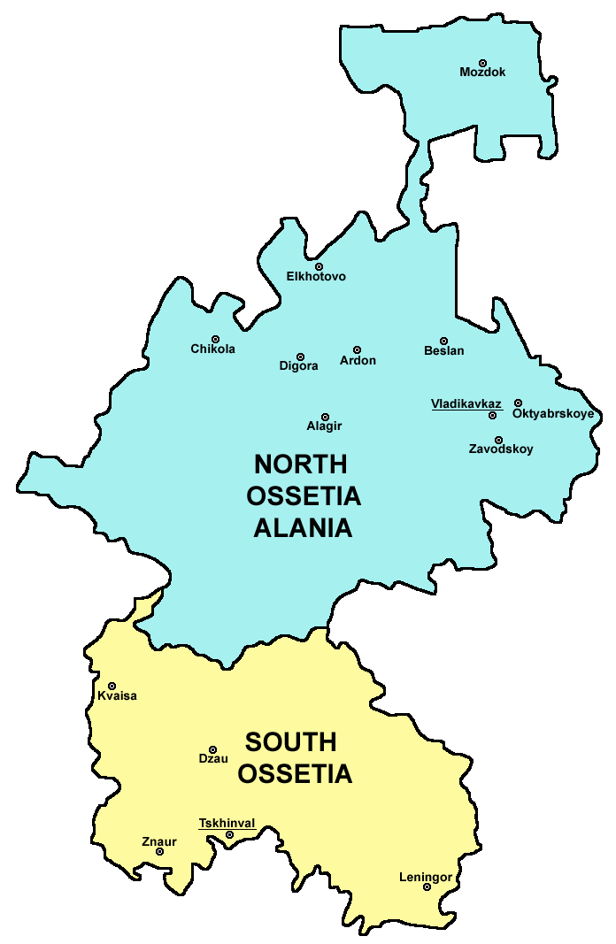
Map of
Ossetia
(North Ossetia and South Ossetia).
|
| Date | 19 December 2006 (original upload date) |
| Source | Own work |
| Author | PANONIAN |
Licensing
self made map by user:PANONIAN
|
|
I, the copyright holder of this work, release this work into the
public domain
. This applies worldwide.
In some countries this may not be legally possible; if so: I grant anyone the right to use this work for any purpose , without any conditions, unless such conditions are required by law. |

|
This map has been uploaded by
Electionworld
from en.wikipedia.org to enable the
|
References
Borders and locations of major settlements:
- http://iratta.com/uploads/posts/atlas/21/karta.jpg
- http://foto.mail.ru/bk/lyks2003/150/163.html
- http://4.bp.blogspot.com/_PB5-El7se4s/SJzcr3lGyAI/AAAAAAAAISU/kagljy4-1b0/s400/ossetia+map.jpg
- http://static.guim.co.uk/sys-images/Guardian/Pix/pictures/2008/8/8/1218195196317/ossetia220.jpg
- http://www.pri.org/theworld/files/images/ossetia_map.jpg
List of larger settlements:
derivative works
Derivative works of this file:
- Ossetia01-he.png
- Osetia del norte y del sur.png
- Ossetia Nord i Sud.png
- Ossetia kaart.png
- Ossetia rus.png
- Ossetia01 (tr).png
- Ossetia-sr.png
- http://en.wikipedia.org/wiki/File:UnitedOssetia.png
.png)