Partition_of_India.PNG

No higher resolution available.

|
This
historical map
image could be re-created
using
vector graphics
as an
SVG
file
. This has several advantages; see
Commons:Media for cleanup
for more information. If an SVG form of this image is available, please upload it and afterwards replace this template with
{{

vector version available

|

new image name

}}
.
It is recommended to name the SVG file “Partition of India.svg”—then the template Vector version available (or Vva ) does not need the new image name parameter. |

|
This map has been uploaded by
Electionworld
from en.wikipedia.org to enable the
|
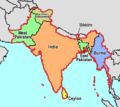
Map showing the Partition of India, by McMullen
|
|
I, the copyright holder of this work, release this work into the
public domain
. This applies worldwide.
In some countries this may not be legally possible; if so: I grant anyone the right to use this work for any purpose , without any conditions, unless such conditions are required by law. |
[
]
-
 English
 -
 English
 -
 Esperanto
 -
 español
 -
 français
 -
 italiano
 -
 magyar
 -
 Bahasa Melayu
 -
 polski
 -
 нохчийн
 -
 русский
 -
 मराठी
मराठी -
 हिन्दी
 -
 বাংলা
বাংলা -
 বাংলা
বাংলা -
 ਪੰਜਾਬੀ
 -
 ગુજરાતી
 -
 ಕನ್ನಡ
ಕನ್ನಡ -
 עברית
עברית -
 سنڌي
سنڌي -
 اردو
اردو -
 العربية
 -
 فارسی
فارسی


.svg)


