Partitions_of_Poland.png

Size of this preview:
765 × 600 pixels
.
Other resolutions:
306 × 240 pixels
|
612 × 480 pixels
|
980 × 768 pixels
|
1,280 × 1,004 pixels
|
2,000 × 1,568 pixels
.
| Description |
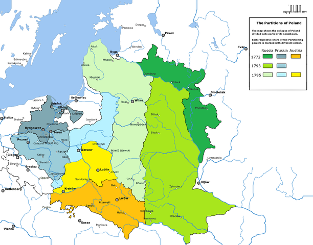
English:
Partitions of the
Polish-Lithuanian Commonwealth
in 1772, 1793 and 1795.
Deutsch:
Die Teilungen
Polen-Litauens
1772, 1793 und 1795.
|
| Date | (UTC) |
| Source | |
| Author |
|
| Other versions | العربيَّة |
|
|
This is a
retouched picture
, which means that it has been digitally altered from its original version. Modifications:
new colours
. The original can be viewed here:
Rzeczpospolita Rozbiory 3.png
:
|

|
This
historical map
image could be re-created
using
vector graphics
as an
SVG
file
. This has several advantages; see
Commons:Media for cleanup
for more information. If an SVG form of this image is available, please upload it and afterwards replace this template with
{{

vector version available

|

new image name

}}
.
It is recommended to name the SVG file “Partitions of Poland.svg”—then the template Vector version available (or Vva ) does not need the new image name parameter. |
I, the copyright holder of this work, hereby publish it under the following license:

|
Permission is granted to copy, distribute and/or modify this document under the terms of the GNU Free Documentation License , Version 1.2 or any later version published by the Free Software Foundation ; with no Invariant Sections, no Front-Cover Texts, and no Back-Cover Texts. A copy of the license is included in the section entitled GNU Free Documentation License . |
|
|
This file is licensed under the Creative Commons Attribution-Share Alike 3.0 Unported license. | |
|
||
| This licensing tag was added to this file as part of the GFDL licensing update . |
Original upload log
This image is a derivative work of the following images:
-
File:Rzeczpospolita_Rozbiory_3.png
licensed with GFDL
- 2006-02-16T21:06:11Z Tomekpe 2000x1568 (246810 Bytes) Corrected mistakes: * Silesia at the time belonged to Prussia, whereas the map shows it belonging to Austria.
- 2005-12-25T21:52:24Z Tomekpe 2000x1568 (247161 Bytes) Halibutt's graphic with changing polish-russian border (Krasny Horodok area).
- 2005-01-10T13:41:59Z Halibutt 2000x1568 (343225 Bytes) Partitions of the [[Polish-Lithuanian Commonwealth]]{{User:Halibutt/maps}}{{User:Halibutt/GFDL}}[[Category:Maps of Poland]][[Category:Historical maps]]
Uploaded with derivativeFX