Piri_reis_world_map_01.jpg

Size of this preview:
449 × 599 pixels
.
Other resolutions:
180 × 240 pixels
|
360 × 480 pixels
|
576 × 768 pixels
|
768 × 1,024 pixels
|
1,964 × 2,619 pixels
.
Summary
|
| Description |
العربية:
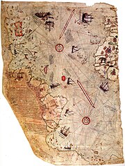
خارطة العالم بِيد أمير البحار العُثماني حاجي أحمد مُحيي الدين پیري، الشهير باسم پيري ريِّس، رُسمت سنة 1513م. لم يبقَ اليوم سوى نصف الخارطة الأصليَّة، التي يُحتفظ بها في متحف سراي طوپ قاپي في إسطنبول. تجمع هذه الخارطة معلومات من حوالي عشرين خريطة أُخرى، بما فيها إحدى الخرائط التي وضعها كريستوفر كولومبوس بنفسه وخطط فيها سواحل العالم الجديد.
English:
Map of the world by Ottoman admiral Piri Reis, drawn in 1513. Only part of the original map survives and is held at the Topkapi Museum in Istanbul. The map synthesizes information from many maps, including one drawn by Christopher Columbus of the Caribbean.
Türkçe:
Osmanlı amirali Piri Reis tarafından 1513'te çizilmiş olan, Avrupa ve Afrika'nın batı kıyılarıyla Güney Amerika'nın doğu kıyılarını gösteren dünyanın en eski haritalarından biri olan Piri Reis'in ilk Dünya haritası.
|
||||||||||||||||||||
| Date | |||||||||||||||||||||
| Source | Library of Topkapi Palace Museum, No. H 1824 Bilkent University (lo res) , erisi.com (hi res) | ||||||||||||||||||||
| Author |
|
||||||||||||||||||||

Licensing
|
This is a faithful photographic reproduction of a two-dimensional,
public domain
work of art. The work of art itself is in the public domain for the following reason:
The official position taken by the Wikimedia Foundation is that "
faithful reproductions of two-dimensional public domain works of art are public domain
".
This photographic reproduction is therefore also considered to be in the public domain in the United States. In other jurisdictions, re-use of this content may be restricted; see Reuse of PD-Art photographs for details. |
||||
| Annotations | This image is annotated: View the annotations at Commons |