Plan_battle_of_Pydna-en.svg

| Description |
Català:
Ordre de la batalla de
Pidna
(168 aC).
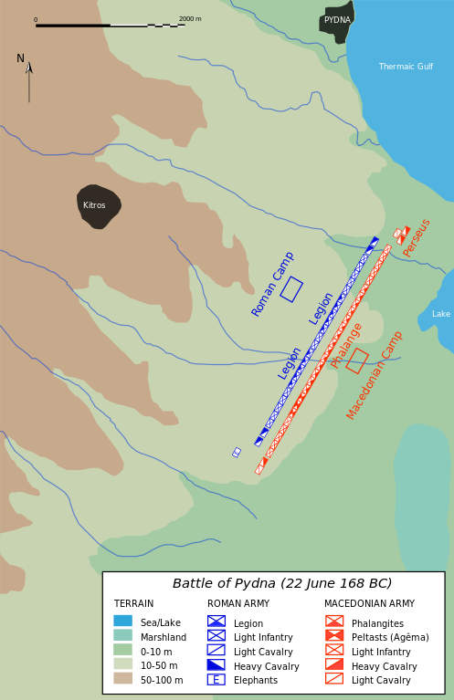
English:
Battle order in
Pydna
(168 BC).
Македонски:
Распоред на силите во битката кај
Пидна
(168 гпне).
|
||||||||
| Date | (original map); 2007-12-08 (English translation) | ||||||||
| Source | Own work using Adobe Illustrator (data based on Hammond & Walbank, History of Macedonia , t. 3, fig. 19, p. 554). Translation into English from Image:Plan battle of Pydna-fr.svg by Mkr bu50 | ||||||||
| Author | Marsyas (original map); Mkr bu50 (English translation) | ||||||||
|
Permission
( Reusing this file ) |
I, the copyright holder of this work, hereby publish it under the following licenses:
This file is licensed under the
Creative Commons
Attribution-Share Alike 2.5 Generic
license.
You may select the license of your choice.
|
||||||||
| Other versions |
Derivative works of this file:
Plan battle of Pydna-zh.svg
File:
Plan battle of Pydna-en.svg
has
2 translations
.
Other related versions: [ ]
|


| Camera location |
|
View this and other nearby images on: OpenStreetMap |
|
|---|

|
This SVG file contains embedded text that can be translated into your language, using any capable SVG editor, text editor or the SVG Translate tool . For more information see: About translating SVG files . |
|
|
This file is
translated using SVG
<switch>
elements
. All translations are stored in the same file!
Learn more
.
For most Wikipedia projects, you can embed the file normally (without a
To translate the text into your language, you can use the SVG Translate tool . Alternatively, you can download the file to your computer, add your translations using whatever software you're familiar with, and re-upload it with the same name. You will find help in Graphics Lab if you're not sure how to do this. |