Population_map_Syria_&_Liban_(1935).jpg
Size of this preview:
766 × 599 pixels
.
Other resolutions:
307 × 240 pixels
|
614 × 480 pixels
|
982 × 768 pixels
|
1,200 × 939 pixels
.
Summary
| Description |
Français :
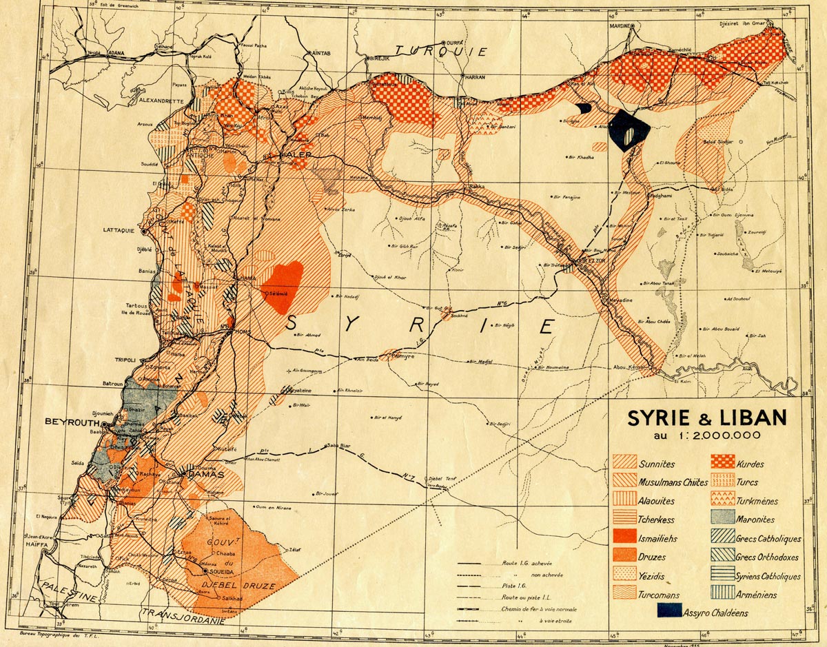
Carte des communautés religieuses et ethniques en Syrie et au Liban (1935). Échelle 1: 200 000; Dimension: 73 × 67 cm.
English:
A map of religious and ethnic communities of Syria and Lebanon (1935). Scale 1: 200 000; Dimension: 73 × 67 cm.
Communities marked are: Sunnis (French: Sunnites ); Shi'ites ( Musulmans Chiites ); Alawites ( Alaouites ); Circassians ( Tcherkess ); Isma'ilis ( Ismailiehs ); Druze ( Druzes ); Yazidis ( Yezidis ); Turkomans ( Turcomans ); Kurds ( Kurdes ); Turkmen ( Turkmènes ); Maronites ( Maronites ); Melkites ( Grecs Catholiques ); Greek Orthodox ( Grecs Orthodoxes ); Syriac Orthodox ( Syriens Catholique ); Arméniens ( Syriens Catholique ); and "Assyro-Chaldeans" ( Assyro-Chaldeéns ).
Türkçe:
Suriye ve Lübnan'ın dini ve etnik topluluklarının haritası (1935). Ölçek 1: 200 000; Boyut: 73 × 67 cm.
|
|||
| Date | ||||
| Source |
Français :
La cartothèque de l'Ifpo (
Institut français du Proche-Orient
)
|
|||
| Author |
Français :
Carte établie par le Bureau topographique des troupes françaises du Levant.
English:
Map prepared by the Bureau of Topographic French troops in the Lebanon.
Türkçe:
Harita Lübnan'da Fransız askeri birliklerinin Topografya Bürosu tarafından hazırlanmıştır.
|
|||
|
Permission
( Reusing this file ) |
|
