Portugal_Colonial_War_1970.jpg
No higher resolution available.

|
This
historical map
image could be re-created
using
vector graphics
as an
SVG
file
. This has several advantages; see
Commons:Media for cleanup
for more information. If an SVG form of this image is available, please upload it and afterwards replace this template with
{{

vector version available

|

new image name

}}
.
It is recommended to name the SVG file “Portugal Colonial War 1970.svg”—then the template Vector version available (or Vva ) does not need the new image name parameter. |


Summary
| Description |
Deutsch:
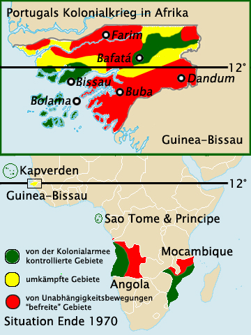
Situation im Portugiesischen Kolonialkrieg Ende 1970
- oben: Guinea-Bissau (nach Urania Atlas, Seyler 1971) - unten: Angola und Mocambique (nach Haack Atlas zur Geschichte, Band 2, Seite 95. Gotha 1982)
English:
Situation in the Portugal´s African Colonial War at the end of the year 1970 in Guinea-Bissau, Angola and Mocambique (green: controlled by Portuguese colonial forces / yellow: fighting area / red: "liberated" by independence movements)
|
| Date | |
| Source | based on File:Guinea-Bissau-map-blank.png and File:Portuguese colonial war map1.PNG |
| Author | Roxanna |
Licensing
I, the copyright holder of this work, hereby publish it under the following license:
This file is licensed under the
Creative Commons
Attribution-Share Alike 3.0 Unported
license.
-
You are free:
- to share – to copy, distribute and transmit the work
- to remix – to adapt the work
-
Under the following conditions:
- attribution – You must give appropriate credit, provide a link to the license, and indicate if changes were made. You may do so in any reasonable manner, but not in any way that suggests the licensor endorses you or your use.
- share alike – If you remix, transform, or build upon the material, you must distribute your contributions under the same or compatible license as the original.