Pridnestrian_Administration.png

Size of this preview:
408 × 599 pixels
.
Other resolutions:
163 × 240 pixels
|
327 × 480 pixels
|
922 × 1,354 pixels
.

|
This
map
image could be re-created
using
vector graphics
as an
SVG
file
. This has several advantages; see
Commons:Media for cleanup
for more information. If an SVG form of this image is available, please upload it and afterwards replace this template with
{{

vector version available

|

new image name

}}
.
It is recommended to name the SVG file “Pridnestrian Administration.svg”—then the template Vector version available (or Vva ) does not need the new image name parameter. |
Summary
| Description |
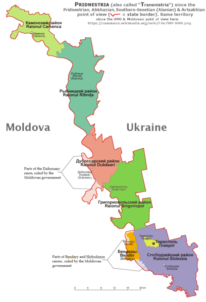
English:
English and according with the official Pridnestrian point of view administrative map of Pridnestria, by Nicolay Sidorov.
|
| Date | |
| Source | Own work |
| Author | derivative map by Spiridon Ion Cepleanu since Aotearoa 's map File:Naddniestrze.png , modified by Николай Сидоров , details by Claude Zygiel according with this [1] official Pridnestrian map. |
| Other versions | File:ПМР-RMN.png showing the UNO & Moldovan point of view about this territory. |
Licensing
I, the copyright holder of this work, hereby publish it under the following license:
This file is licensed under the
Creative Commons
Attribution-Share Alike 4.0 International
license.
-
You are free:
- to share – to copy, distribute and transmit the work
- to remix – to adapt the work
-
Under the following conditions:
- attribution – You must give appropriate credit, provide a link to the license, and indicate if changes were made. You may do so in any reasonable manner, but not in any way that suggests the licensor endorses you or your use.
- share alike – If you remix, transform, or build upon the material, you must distribute your contributions under the same or compatible license as the original.