Queens_Road_-_geograph.org.uk_-_212549.jpg
No higher resolution available.
Summary
| Description |
English:
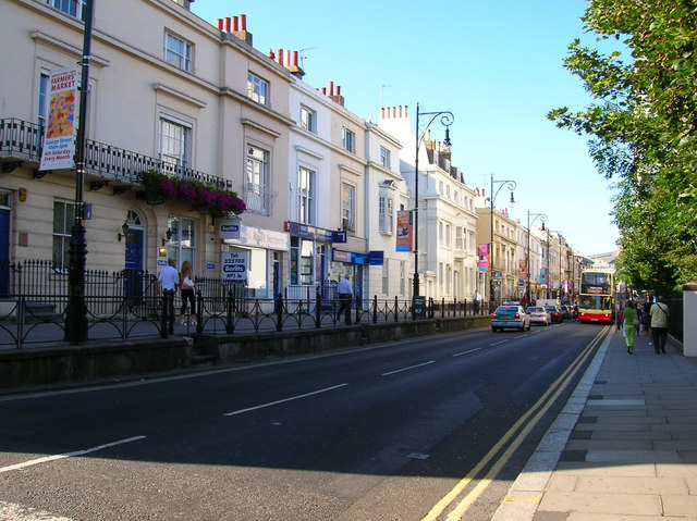
Queens Road. Taken from the junction of Church Street and Queens Road. Queens Road was constructed in 1845 to connect Brighton town centre with the newly opened Brighton station. Parts of the route were already occupied, to the south of this junction was Air Street a small slum area part of which still links Queens Road to Queens Square, whilst to the north was Windsor Terrace constructed in the 1830s. Unlike the slums Windsor Terrace still survives today as does the original walkway originally built next to a graveyard part of which survives to the right of the road today and is now a small park. The new road was built at a higher elevation than the old graveyard but lower than Windsor Terrace. The white building in the middle of the terrace is a Freemasons Lodge constructed in the 1920s.
Click on the link to take you to the next page.
https://www.geograph.org.uk/photo/212550
|
| Date | |
| Source | From geograph.org.uk |
| Author | Simon Carey |
|
Attribution
( required by the license ) |
Simon Carey / Queens Road / |
| Camera location |
|
View this and other nearby images on: OpenStreetMap |
|
|---|
_heading:45.00&language=en)
| Object location |
|
View this and other nearby images on: OpenStreetMap |
|
|---|
_heading:45.00&language=en)
Licensing

|
This image was taken from the
Geograph project
collection. See
this photograph's page
on the Geograph website for the photographer's contact details. The copyright on this image is owned by
Simon Carey
and is licensed for reuse under the
Creative Commons
Attribution-ShareAlike 2.0 license.
|
This file is licensed under the
Creative Commons
Attribution-Share Alike 2.0 Generic
license.
Attribution:
Simon Carey
-
You are free:
- to share – to copy, distribute and transmit the work
- to remix – to adapt the work
-
Under the following conditions:
- attribution – You must give appropriate credit, provide a link to the license, and indicate if changes were made. You may do so in any reasonable manner, but not in any way that suggests the licensor endorses you or your use.
- share alike – If you remix, transform, or build upon the material, you must distribute your contributions under the same or compatible license as the original.