Rajendra_map_new.svg

Size of this PNG preview of this SVG file:
466 × 333 pixels
.
Other resolutions:
320 × 229 pixels
|
640 × 457 pixels
|
1,024 × 732 pixels
|
1,280 × 915 pixels
|
2,560 × 1,829 pixels
.
Summary
| Description |
per
http://cw.routledge.com/textbooks/9780415485432/15.asp
"THE CŌḶAS" by K. A. Nilakanta Sastri and other histories of South Asia consulted.
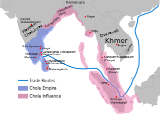
The file has several changes from the original. The map is corrected to show are of influence and direct control in Sri Lanka. Correction was based on the work of Spencer, G. (1976). The Politics of Plunder: The Cholas in Eleventh-Century Ceylon. The Journal of Asian Studies, 35(3), 405-419. doi:10.2307/2053272. The correction about the Chola influence in Malay areas is based on https://archive.org/details/earlykingdomsofi0000muno/page/118/mode/2up The influence added the area of Lamuri based on Tanjore inscription. Andaman is deleted leaving only Nicobar (information on Tanjore inscription). |
| Date | (UTC) |
| Source | |
| Author |
|
|
|
This is a
retouched picture
, which means that it has been digitally altered from its original version. Modifications:
Redrew png as svg
. The original can be viewed here:
Rajendra map new.png
:
|
I, the copyright holder of this work, hereby publish it under the following licenses:
|
|
This file is licensed under the Creative Commons Attribution-Share Alike 3.0 Unported license. Subject to disclaimers . | |
|
||
| This licensing tag was added to this file as part of the GFDL licensing update . |

|
Permission is granted to copy, distribute and/or modify this document under the terms of the GNU Free Documentation License , Version 1.2 or any later version published by the Free Software Foundation ; with no Invariant Sections, no Front-Cover Texts, and no Back-Cover Texts. A copy of the license is included in the section entitled GNU Free Documentation License . |
You may select the license of your choice.
Original upload log
This image is a derivative work of the following images:
-
File:Rajendra_map_new.png
licensed with Cc-by-sa-3.0-migrated-with-disclaimers, GFDL-en, GFDL-user-en-with-disclaimers
- 2011-03-21T12:16:23Z Gregors 600x429 (102117 Bytes) Bitmap of svg that i will soon upload. ~~~~
- 2009-06-07T09:04:06Z Maukie 629x442 (215021 Bytes) {{Information |Description={{en|Map showing the extent of the [[:en:Chola empire|]] during [[:en:Rajendra Chola I|]] (c. 1030 CE)}} |Source=Transferred from [http://en.wikipedia.org en.wikipedia]; transfer was stated to be ma
Uploaded with derivativeFX