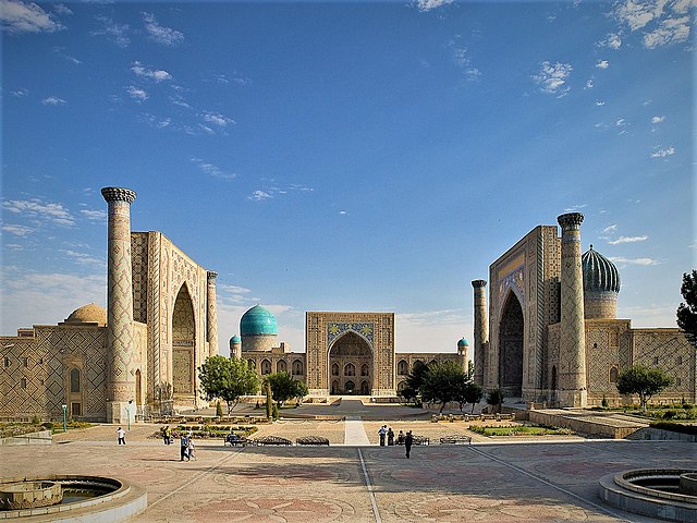
RegistanSquare_Samarkand.jpg

Size of this preview:
799 × 600 pixels
.
Other resolutions:
320 × 240 pixels
|
640 × 480 pixels
|
1,024 × 768 pixels
|
1,280 × 960 pixels
|
1,462 × 1,097 pixels
.
| Description |
Lëtzebuergesch:
D'Registan Plaz zu Samarkand.
|
| Date | (UTC) |
| Source | |
| Author |
|
| Camera location |
|
View this and other nearby images on: OpenStreetMap |
|
|---|
|
|
This is a
retouched picture
, which means that it has been digitally altered from its original version. Modifications:
perspective correction
. The original can be viewed here:
Registan - Gusjer.jpg
:
|
I, the copyright holder of this work, hereby publish it under the following license:
This file is licensed under the
Creative Commons
Attribution 2.0 Generic
license.
-
You are free:
- to share – to copy, distribute and transmit the work
- to remix – to adapt the work
-
Under the following conditions:
- attribution – You must give appropriate credit, provide a link to the license, and indicate if changes were made. You may do so in any reasonable manner, but not in any way that suggests the licensor endorses you or your use.
Original upload log
This image is a derivative work of the following images:
-
File:Registan_-_Gusjer.jpg
licensed with Cc-by-2.0
- 2009-06-12T22:34:18Z Kordas 1600x1200 (697379 Bytes) {{Information |Description= [http://whc.unesco.org/en/list/603 whc.unesco.org/en/list/603] |Source=[http://www.flickr.com/photos/20244534@N00/3087484514/ Registan] |Date=2008-08-03 03:58 |Author=[http://www.flickr.com/people/
Uploaded with derivativeFX
| Annotations | This image is annotated: View the annotations at Commons |


|
This image has been assessed under the valued image criteria and is considered the most valued image on Commons within the scope: Registan Square, Samarkand . You can see its nomination here . |