Relief_Map_of_Brazil.jpg

Size of this preview:
607 × 600 pixels
.
Other resolutions:
243 × 240 pixels
|
486 × 480 pixels
|
777 × 768 pixels
|
1,200 × 1,186 pixels
.
| Description |
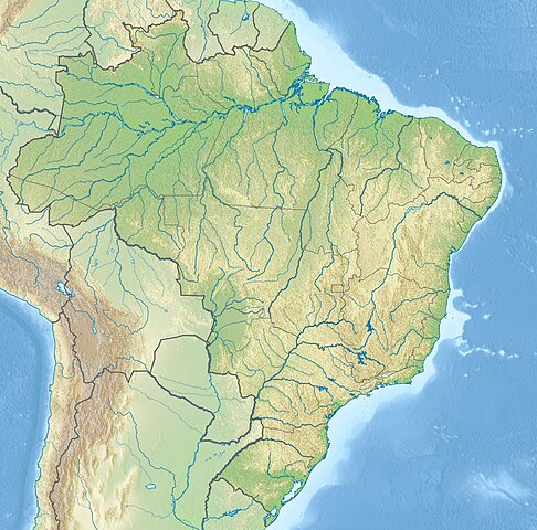
English:
Location map of
Brazil
Equirectangular projection, N/S stretching 105 %. Geographic limits of the map:
|
|||
| Date | (UTC) | |||
| Source |
|
|||
| Author |
|
|||
| Other versions |
|


|
|
This is a
retouched picture
, which means that it has been digitally altered from its original version. The original can be viewed here:
Brazil location map.svg
:
|
I, the copyright holder of this work, hereby publish it under the following license:
This file is licensed under the
Creative Commons
Attribution-Share Alike 3.0 Unported
license.
-
You are free:
- to share – to copy, distribute and transmit the work
- to remix – to adapt the work
-
Under the following conditions:
- attribution – You must give appropriate credit, provide a link to the license, and indicate if changes were made. You may do so in any reasonable manner, but not in any way that suggests the licensor endorses you or your use.
- share alike – If you remix, transform, or build upon the material, you must distribute your contributions under the same or compatible license as the original.
Original upload log
This image is a derivative work of the following images:
-
File:Brazil_location_map.svg
licensed with Cc-by-sa-3.0
- 2009-08-05T19:53:55Z NordNordWest 2008x1984 (1674058 Bytes) {{int:filedesc}} {{Information |Description= {{de|Positionskarte von [[:de:Brasilien|Brasilien]]}} Quadratische Plattkarte, N-S-Streckung 105 %. Geographische Begrenzung der Karte: * N: 6.0° N * S: 34.0° S * W: 74.5° W * O
Uploaded with derivativeFX