RomanEmpire_117.svg

Size of this PNG preview of this SVG file:
512 × 376 pixels
.
Other resolutions:
320 × 235 pixels
|
640 × 470 pixels
|
1,024 × 752 pixels
|
1,280 × 940 pixels
|
2,560 × 1,880 pixels
.
Summary
| Description |
English:
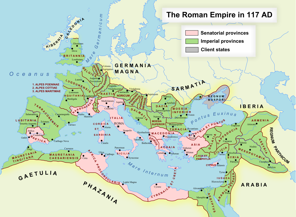
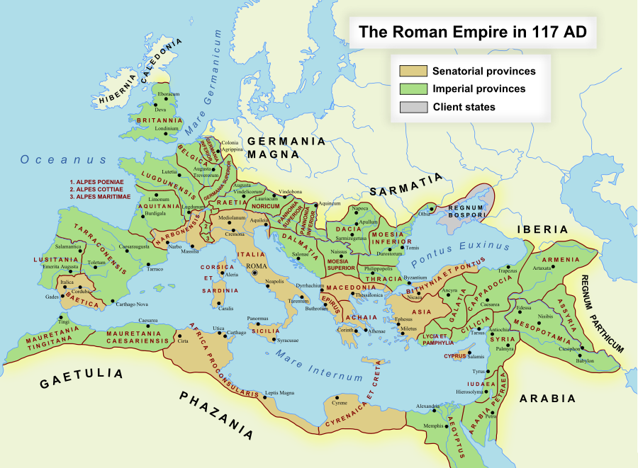
The maximum extent of the Roman Empire. Superimposed on a physical map.
Senatorial Provinces
Imperial Provinces
Client States
Español:
Máxima extensión del Imperio Romano. Superpuesto en un mapa físico.
Provincias Senatoriales
Provincias Imperiales
Estados satélite
Deutsch:
Das Römische Reich zur Zeit seiner maximalen Ausdehnung unter Trajan, 117 n. Chr.
Senatorische Provinz
Kaiserliche Provinz
Klientelkönigtum
Latina:
Extentum maximum de Imperium Romanum.
Provinciae senatus
Provinciae Imperii
Civitates Clientes
中文:
公元117年图拉真在位时期罗马帝国的最大疆域。
元老院行省
元首行省
附庸国
日本語:
ローマ帝国の最大版図。(西暦117年、皇帝トラヤヌス)
元老院属州
皇帝属州
従属国
|
| Date | 17 October 2005 (first version); 19 December 2007 (last version) |
| Source | Transferred from en.wikipedia to Commons. |
| Author | ArdadN at English Wikipedia |
|
Permission
( Reusing this file ) |
Public Domain |
| Other versions |
[
]
|
| SVG development |


SVG Support
This document is in the Scalable Vector Graphic format (SVG) and requires a supported browser (Firefox, Google Chrome, Opera) or a SVG plugin for Internet Explorer and other browsers. SVG is an open, text-based format, which means this map can be downloaded and modified/translated completely using a vector graphics editor like Adobe Illustrator or Inkscape (free) or a text editor such as Notepad .
| BLANK THUMBNAIL | View large PNG | View medium PNG | SVG Plugin for Internet Explorer and other browsers |
|---|---|---|---|
| Click here (purge cache) and then CTRL + F5 to reload. Help? | Try 1 Try 2 | Try 1 Try 2 | Adobe SVG plugin |
| Recommended browser | More Help | ||
| Firefox | List of SVG tools |
Licensing
ArdadN
at
English Wikipedia
, the copyright holder of this work, hereby publishes it under the following license:
|
|
I, the copyright holder of this work, release this work into the
public domain
. This applies worldwide.
In some countries this may not be legally possible; if so: I grant anyone the right to use this work for any purpose , without any conditions, unless such conditions are required by law. |