Sardegna_precipitazioni.svg

Size of this PNG preview of this SVG file:
284 × 600 pixels
.
Other resolutions:
113 × 240 pixels
|
227 × 480 pixels
|
363 × 768 pixels
|
485 × 1,024 pixels
|
969 × 2,048 pixels
|
491 × 1,037 pixels
.
Summary
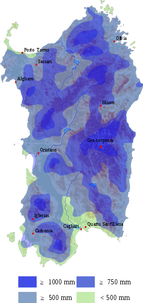
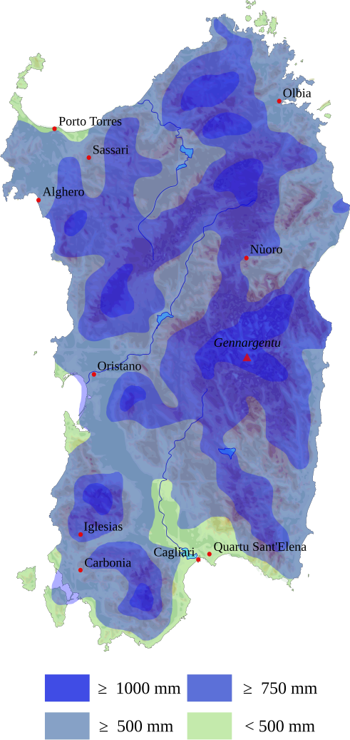
| Description | Mappa delle precipitazioni della Sardegna. Fonte: Carta della precipitazione media annua in Italia per il trentennio 1921-1950 / P. Frosini. - Roma - Istituto poligrafico dello Stato-Libreria, 1961. Ministero dei lavori pubblici - Consiglio superiore, Servizio idrografico. Collana Pubblicazioni del Consiglio superiore del Servizio idrografico ; 24.13. Atti del Seminario di studi sulle acque in Sardegna indetto dall'on. dott. Salvatore Campus assessore ai lavori pubblici della Regione autonoma della Sardegna, Cagliari 22-23-24-25 febbraio 1968, patrocinato ed organizzato dall'Assessorato ai lavori pubblici con la collaborazione dell'Istituto di idraulica dell'Universita di Cagliari. Società editoriale italiana, XXIII. |
| Date | (UTC) |
| Source |
This file was derived from:
Sardegna.svg
:

|
| Author |
|
|
|
This is a
retouched picture
, which means that it has been digitally altered from its original version. Modifications:
Added rain map layer
. The original can be viewed here:
Sardegna.svg
:
|
Licensing
I, the copyright holder of this work, hereby publish it under the following license:
This file is licensed under the
Creative Commons
Attribution-Share Alike 2.5 Generic
license.
-
You are free:
- to share – to copy, distribute and transmit the work
- to remix – to adapt the work
-
Under the following conditions:
- attribution – You must give appropriate credit, provide a link to the license, and indicate if changes were made. You may do so in any reasonable manner, but not in any way that suggests the licensor endorses you or your use.
- share alike – If you remix, transform, or build upon the material, you must distribute your contributions under the same or compatible license as the original.
Original upload log
This image is a derivative work of the following images:
-
File:Sardegna.svg
licensed with Cc-by-sa-2.5
- 2010-01-14T21:01:02Z S141739 501x932 (3125642 Bytes) added major town, +rescale some colors
- 2009-12-28T01:25:50Z Larry Yuma 501x932 (3124657 Bytes) more terrain details
- 2009-12-26T17:27:43Z Larry Yuma 501x932 (2974599 Bytes) terrain
- 2009-12-26T17:26:11Z Larry Yuma 501x932 (2974599 Bytes) terrain
- 2009-12-26T16:39:11Z Larry Yuma 501x932 (105385 Bytes) {{Information |Description=Sardinia map |Source=*[[:File:Localització_de_l'Alguer_respecte_de_Sardenya.svg|]] |Date=2009-12-26 16:37 (UTC) |Author=*[[:File:Localització_de_l'Alguer_respecte_de_Sardenya.svg|]]: [[User:Ebren
Uploaded with derivativeFX