ScotlandTradNumbered.png
No higher resolution available.

|
This
locator map
image could be re-created
using
vector graphics
as an
SVG
file
. This has several advantages; see
Commons:Media for cleanup
for more information. If an SVG form of this image is available, please upload it and afterwards replace this template with
{{

vector version available

|

new image name

}}
.
It is recommended to name the SVG file “ScotlandTradNumbered.svg”—then the template Vector version available (or Vva ) does not need the new image name parameter. |
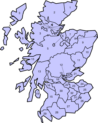
Traditional counties of Scotland
Slightly edited version of a map originally drawn by Morwen
- Caithness
- Sutherland
- Ross-shire
- Cromartyshire
- Inverness-shire
- Nairnshire
- Morayshire
- Banffshire
- Aberdeenshire
- Kincardineshire
- Angus
- Perthshire
- Argyll
- Bute
- Ayrshire
- Renfrewshire
- Dunbartonshire
- Stirlingshire
- Clackmannanshire
- Kinross-shire
- Fife
- West Lothian
- Mid Lothian
- East Lothian
- Berwickshire
- Roxburghshire
- Dumfriesshire
- Kirkcudbrightshire
- Wigtownshire
- Lanarkshire
- Selkirkshire
- Peeblesshire

|
Permission is granted to copy, distribute and/or modify this document under the terms of the GNU Free Documentation License , Version 1.2 or any later version published by the Free Software Foundation ; with no Invariant Sections, no Front-Cover Texts, and no Back-Cover Texts. A copy of the license is included in the section entitled GNU Free Documentation License . |
|
|
This file is licensed under the Creative Commons Attribution-Share Alike 3.0 Unported license. | |
|
||
| This licensing tag was added to this file as part of the GFDL licensing update . |