Scythian_capital_and_royal_kurgans.png
No higher resolution available.
-
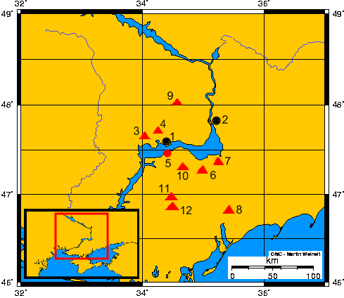
Opis mapy - Description of the map:
-
1) Nikopol (współczesne miasto/modern town)
-
2) Zaporoże (współczesne miasto) - Zaporizhia (modern town)
-
3) Tołstaja Mogiła (kurhan) - Towstaya Mogila (kurgan)
-
4) Czertomłyk (kurhan) - Chertomlyk (kurgan)
-
5) Grodzisko Kamienskoje – Kamienskoye settlement
-
6) Sołocha (kurhan) – Solokha (kurgan)
-
7) Gajmanowa Mogiła (kurhan) - Gaymanova Mogila
-
8) Kurhan Melitopolski - Melitopol's kurgan
-
9) Kurhan Aleksandropolski - Alexandropol's kurgan
-
10) Bolszaja Cymbałka (kurhan) - Bolshaya Tsymbalka (kurgan)
-
11) Kozieł (kurhan) - Kozel (kurgan)
-
12) Oguz (kurhan) - Oguz (kurgan)
-
1) Nikopol (współczesne miasto/modern town)
| Description |
English:
Ancient scythian town-capital Kamienskoje and so-called royal scytians kurgans on grounds of the Lower Dnieper
Español:
La antigua ciudad – capital Kamienskoie y así llamados real kurganos de escitas al curso bajo del Río Dniéper
Polski:
Starożytne miasto–stolica Kamienskoje i tzw. królewskie kurhany scytyjskie nad dolnym Dnieprem
Русский:
Каменское городище-столица Скифии и так называемые царские курганы Скифии в нижнем течении Днепра
|
||
| Date | 10-12.11.2007 | ||
| Source | Own work ; on the basis of maps from historical books and WWW | ||
| Author | Janmad | ||
|
Permission
( Reusing this file ) |
I, the copyright holder of this work, hereby publish it under the following licenses:
This file is licensed under the
Creative Commons
Attribution 3.0 Unported
license.
You may select the license of your choice.
|
