SeattleI5Skyline.jpg

Size of this preview:
800 × 479 pixels
.
Other resolutions:
320 × 192 pixels
|
640 × 384 pixels
|
1,024 × 614 pixels
|
1,280 × 767 pixels
|
2,560 × 1,534 pixels
|
4,013 × 2,405 pixels
.
|


|
|
This image was selected as
picture of the day
on Wikimedia Commons for
29 August 2007
. It was captioned as follows:
English:
The skyline of
Seattle, Washington
at dusk.
Other languages:
English
:
The skyline of
Seattle, Washington
at dusk.
Galego
:
Seattle, Washington
Íslenska
:
Útlínur miðborgar
Seattle
í ljósaskiptunum.
Italiano
:
La skyline di
Seattle
al tramonto.
Magyar
:
Seattle-i
szürkület
Svenska
:
Seattles
skyline i skymningen.
Türkçe
:
"Zümrüt Kent" olarak da anılan
Seattle
'ın alacakaranlıktaki görünümü
Русский
:
Панорама
Сиэтла
в сумерках
Українська
:
Силует міста Сіетл (США) в сутінках.
日本語
:
アメリカ、ワシントン州
シアトル
の夕暮れ
العربية
:
منظر عام وقت الغروب لمدينة
سياتل
و الموجودة في
ولاية واشنطن
على الساحل الغربي للولايات المتحدة الأمريكية
|
| Description |
English:
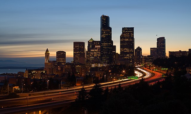
The skyline of Seattle, Washington at dusk. Interstate 5 is the freeway that cuts through downtown and Puget Sound is visible to the left.
فارسی:
نگارهای از آسمان در غروب شهر سیاتل در ایالت واشینگتن که آزاد را پنجم را به نقش کشیده است.
Français :
Le quartier d'affaire de Seattle (État de Washington, USA) au coucher du soleil. Le quartier est traversé par l'Interstate 5, qui est ici une autoroute. Sur la gauche de l'image, on aperçoit Puget Sound.
Русский:
Вид г. Сиэтла (штат Вашингтон, США) в сумерках. Шоссе "Интерстэйт 5" проходит через центр города, слева виден залив Пьюджет-Саунд.
Türkçe:
"Zümrüt Kent" olarak da anılan Seattle'ın alacakaranlıktaki görünümü.
|
||||||||
| Date | |||||||||
| Source | Own work | ||||||||
| Author | Cacophony | ||||||||
|
Permission
( Reusing this file ) |
I,
Cacophony
, the copyright holder of this work, hereby publishes it under the following licenses:
This file is licensed under the
Creative Commons
Attribution-Share Alike
2.5 Generic
,
2.0 Generic
and
1.0 Generic
license.
Attribution:
I,
Cacophony
You may select the license of your choice.
|

| Camera location |
|
View this and other nearby images on: OpenStreetMap |
|
|---|

|
This image has been assessed under the valued image criteria and is considered the most valued image on Commons within the scope: Seattle skylines from Jose P. Rizal Park (dusk) . You can see its nomination here . |