Shipping_routes_red_black.png

Size of this preview:
800 × 400 pixels
.
Other resolutions:
320 × 160 pixels
|
640 × 320 pixels
|
1,024 × 512 pixels
|
1,280 × 640 pixels
|
3,600 × 1,800 pixels
.

|
This
map
image could be re-created
using
vector graphics
as an
SVG
file
. This has several advantages; see
Commons:Media for cleanup
for more information. If an SVG form of this image is available, please upload it and afterwards replace this template with
{{

vector version available

|

new image name

}}
.
It is recommended to name the SVG file “Shipping routes red black.svg”—then the template Vector version available (or Vva ) does not need the new image name parameter. |
Summary
| Description |
English:
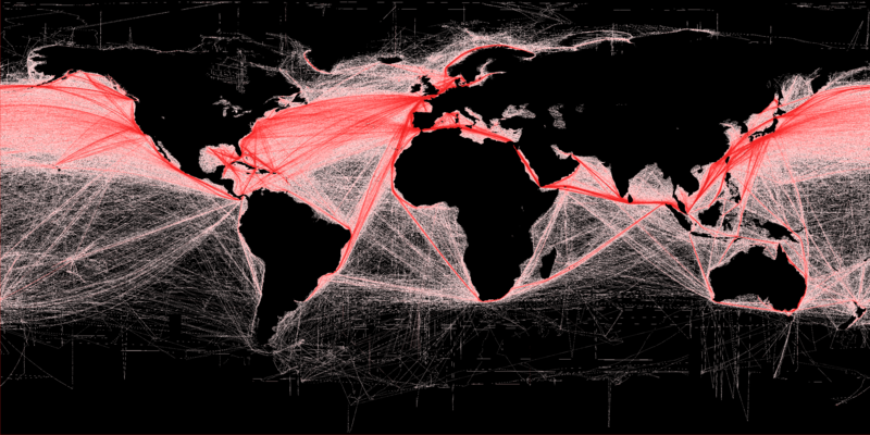
Shipping density (commercial). A Global Map of Human Impacts to Marine Ecosystems, showing relative density (in color) against a black background. Scale: 1 km.
More details available at: http://spatial-analyst.net/worldmaps/shipping.rdc |
| Date | |
| Source |
Own work using:
|
| Author | Grolltech (derived from Hengl (derived from B.S. Halpern)) |
| Other versions |
This file was derived from:
Shipping routes.png
:

|
|
Attribution
( required by the license ) |
B.S. Halpern (T. Hengl; D. Groll) / Wikimedia Commons / |
Licensing
I, the copyright holder of this work, hereby publish it under the following license:
This file is licensed under the
Creative Commons
Attribution-Share Alike 3.0 Unported
license.
-
You are free:
- to share – to copy, distribute and transmit the work
- to remix – to adapt the work
-
Under the following conditions:
- attribution – You must give appropriate credit, provide a link to the license, and indicate if changes were made. You may do so in any reasonable manner, but not in any way that suggests the licensor endorses you or your use.
- share alike – If you remix, transform, or build upon the material, you must distribute your contributions under the same or compatible license as the original.