Sint_Maarten-CIA_WFB_Map.png
No higher resolution available.

|
This
locator map
image could be re-created
using
vector graphics
as an
SVG
file
. This has several advantages; see
Commons:Media for cleanup
for more information. If an SVG form of this image is available, please upload it and afterwards replace this template with
{{

vector version available

|

new image name

}}
.
It is recommended to name the SVG file “Sint Maarten-CIA WFB Map.svg”—then the template Vector version available (or Vva ) does not need the new image name parameter. |
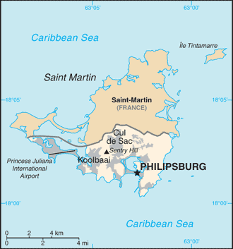
| Description | Map of Sint Maarten from the 2010-10-22 revision of the World Factbook |
| Date | |
| Source | World Factbook website |
| Author | Directorate of Intelligence, CIA |
|
|
This image is in the
public domain
because it contains materials that originally came from the United States
Central Intelligence Agency
's
World Factbook
.
|

|