Summary
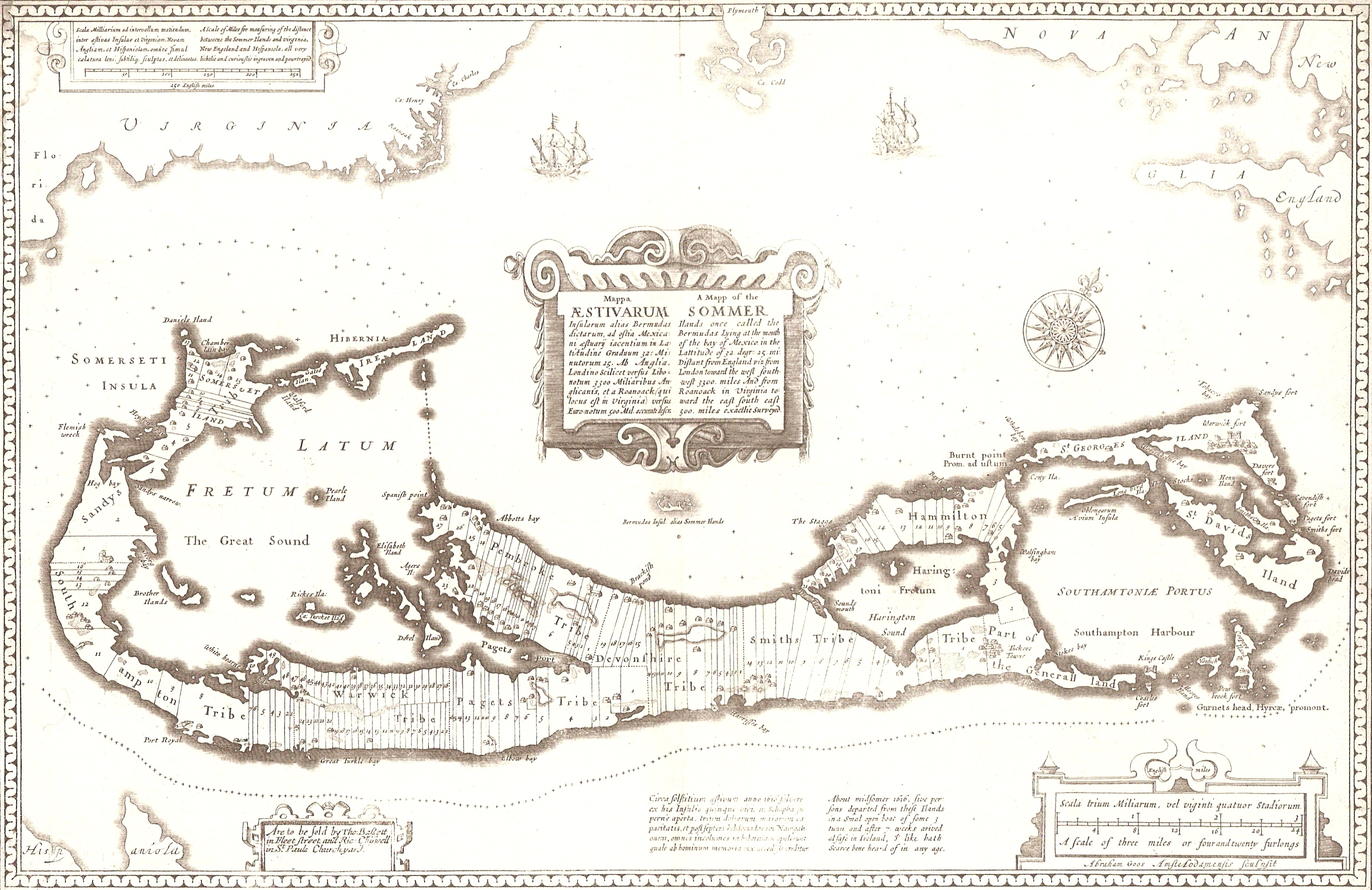
A 1676 map of the Somers Isles (alias Bermuda), by John Speed (based on the map of surveyor Richard Norwood). Clearly shown are the tribe roads cut parallel through the forest between the North and South Shores (except in St. Georges, the eastern-most subdivision, comprising the islands of St. George's and St. David's, the South-Eastern tip of the Main Island, and the various smaller islands between. This was general land, and not commercial.
Aodhdubh
06:04, 26 February 2007 (UTC)
Licensing
|
Public domain
Public domain
false
false
|

|
This work is in the
public domain
in its country of origin and other countries and areas where the
copyright term
is the author's
life plus 70 years or fewer
.
 You must also include a
United States public domain tag
to indicate why this work is in the public domain in the United States. Note that a few countries have copyright terms longer than 70 years: Mexico has 100 years, Jamaica has 95 years, Colombia has 80 years, and Guatemala and Samoa have 75 years. This image may
not
be in the public domain in these countries, which moreover do
not
implement the
rule of the shorter term
. Honduras has a general copyright term of 75 years, but it
does
implement the rule of the shorter term. Copyright may extend on works created by French who died for France in
World War II
(
more information
), Russians who served in
the Eastern Front of World War II
(known as the Great Patriotic War in Russia) and posthumously
rehabilitated
victims of Soviet repressions (
more information
).
You must also include a
United States public domain tag
to indicate why this work is in the public domain in the United States. Note that a few countries have copyright terms longer than 70 years: Mexico has 100 years, Jamaica has 95 years, Colombia has 80 years, and Guatemala and Samoa have 75 years. This image may
not
be in the public domain in these countries, which moreover do
not
implement the
rule of the shorter term
. Honduras has a general copyright term of 75 years, but it
does
implement the rule of the shorter term. Copyright may extend on works created by French who died for France in
World War II
(
more information
), Russians who served in
the Eastern Front of World War II
(known as the Great Patriotic War in Russia) and posthumously
rehabilitated
victims of Soviet repressions (
more information
).
|
|
This file has been identified as being free of known restrictions under copyright law, including all related and neighboring rights.
|
https://creativecommons.org/publicdomain/mark/1.0/
PDM
Creative Commons Public Domain Mark 1.0
false
false