SouthIsland_rrMap_v02.svg

Size of this PNG preview of this SVG file:
446 × 599 pixels
.
Other resolutions:
178 × 240 pixels
|
357 × 480 pixels
|
571 × 768 pixels
|
762 × 1,024 pixels
|
1,524 × 2,048 pixels
|
744 × 1,000 pixels
.
Summary
| Description |
English:
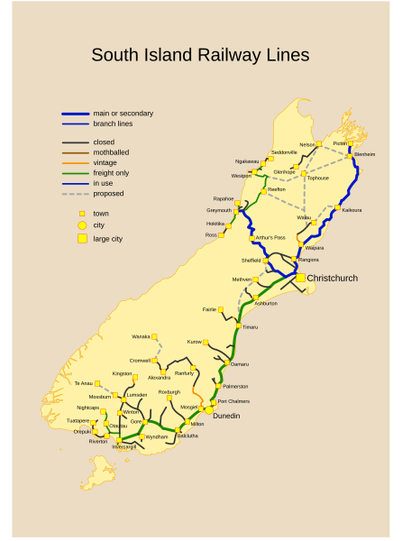
South Island Rail Network Map. List of New Zealand railway lines.
Nederlands:
South Island Rail.
English:
Past, Current and Proposed Railways of NZ South Island.
Viewers might need an SVG capable browser to see this map in full size. |
| Date |
6 November 2006 (original upload date)
|
| Source |
Starting source map (landmass and railways) before refinement and
simplification from: www.demis.nl |
| Author | ( Original text: Emanuele D'Arrigo ) |
Licensing
|
|
This work has been released into the
public domain
by its author,
Manu3d
at
English Wikipedia
. This applies worldwide.
In some countries this may not be legally possible; if so: Manu3d grants anyone the right to use this work for any purpose , without any conditions, unless such conditions are required by law. |
Original upload log
The original description page was
here
. All following user names refer to en.wikipedia.
- 2006-11-06 15:41 Manu3d 744×1000×0 (71902 bytes) == Summary == {{Information |Description=Past, Current and Proposed Railways of NZ South Island. <br />Viewers might need an SVG capable browser to see this map in full size. |Source=Starting source map (landmass and railways) before refinement and <br />