Southeast_Indian_Ocean_cyclone_tracks_1980-2005.jpg

Size of this preview:
666 × 599 pixels
.
Other resolutions:
267 × 240 pixels
|
533 × 480 pixels
|
853 × 768 pixels
|
1,138 × 1,024 pixels
|
2,276 × 2,048 pixels
|
3,000 × 2,700 pixels
.
Summary
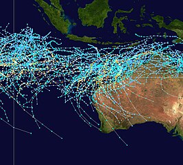
| Saffir-Simpson Hurricane Scale | ||||||
| TD | TS | 1 | 2 | 3 | 4 | 5 |
This map shows the tracks of all Tropical cyclones in the Southeast Indian Ocean from 1980 to 2005. 90° E longitude is marked on the map, this is the western boundary of the basin. The points show the locations of the storms at six-hourly intervals and use the color scheme shown above from Saffir-Simpson Hurricane Scale .
Licensing
Created using User:jdorje/Tracks by Nilfanion on 2007-02-19 . Background image from Image:Whole world - land and oceans.jpg ( NASA ). The best track information is from the Joint Typhoon Warning Center . [1]
|
|
I, the copyright holder of this work, release this work into the
public domain
. This applies worldwide.
In some countries this may not be legally possible; if so: I grant anyone the right to use this work for any purpose , without any conditions, unless such conditions are required by law. |