St_James's_Church,_Manorbier_-_geograph.org.uk_-_928738.jpg
No higher resolution available.
|
|
This is a photo of
listed building
number
5975
.
|
Summary
| Description |
English:
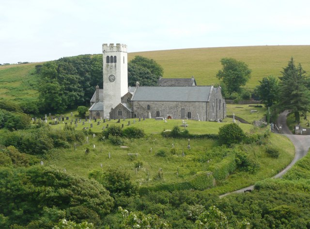
St James's Church, Manorbier 12C church restored by F Wehnert in 1865, when the rood screen was removed and the E window replaced by the present one. The entrance is via a vaulted porch with a medieval painting. The Norman nave has strong walls into which arches have been formed to the 14C aisles. The tower is in an unusual position in the angle between the chancel, rebuilt 13C, and the N transept.
|
| Date | |
| Source | From geograph.org.uk |
| Author | Humphrey Bolton |
|
Attribution
( required by the license ) |
Humphrey Bolton / St James's Church, Manorbier / |
| Camera location |
|
View this and other nearby images on: OpenStreetMap |
|
|---|
_heading:157.00&language=en)
| Object location |
|
View this and other nearby images on: OpenStreetMap |
|
|---|
_heading:157.00&language=en)
Licensing

|
This image was taken from the
Geograph project
collection. See
this photograph's page
on the Geograph website for the photographer's contact details. The copyright on this image is owned by
Humphrey Bolton
and is licensed for reuse under the
Creative Commons
Attribution-ShareAlike 2.0 license.
|
This file is licensed under the
Creative Commons
Attribution-Share Alike 2.0 Generic
license.
Attribution:
Humphrey Bolton
-
You are free:
- to share – to copy, distribute and transmit the work
- to remix – to adapt the work
-
Under the following conditions:
- attribution – You must give appropriate credit, provide a link to the license, and indicate if changes were made. You may do so in any reasonable manner, but not in any way that suggests the licensor endorses you or your use.
- share alike – If you remix, transform, or build upon the material, you must distribute your contributions under the same or compatible license as the original.