The_Mali_Empire.jpg

Size of this preview:
800 × 600 pixels
.
Other resolutions:
320 × 240 pixels
|
640 × 480 pixels
|
1,024 × 768 pixels
|
1,280 × 960 pixels
|
2,560 × 1,920 pixels
|
3,000 × 2,250 pixels
.


Summary
| Description |
English:
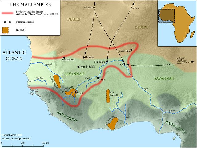
The Medieval Mali Empire at the end of Mansa Musa's reign (1337 CE)
Map Sources: Physical elevation representation comes from public-domain SRTM data. Coastlines follow the Barrington Atlas of the Ancient World (Princeton University Press, 2000)--while Mali hardly falls within the time period covered by this atlas, these coastlines omit major harbor construction in the modern period, and are accurate at the scale of the map. Rivers adapted from ESRI user contributions, or traced from satellite imagery. Ecological zones based on "A New Map of Standardized Terrestrial Ecosystems of Africa" (Association of American Geographers, 2013). Historical data drawn from Robert Collins and James Burns, "A History of Sub-Saharan Africa" (Cambridge University Press, 2007) (see esp. p. 86). Adapted and expanded based on lecture materials from Dr. Lisa Lindsay at the University of North Carolina-Chapel Hill, and from this map by wikimedia user Aa77zz: https://commons.wikimedia.org/wiki/File:Trans-Saharan_routes_early.svg |
| Date | |
| Source | Own work |
| Author | Gabriel Moss |
Licensing
I, the copyright holder of this work, hereby publish it under the following license:
This file is licensed under the
Creative Commons
Attribution-Share Alike 4.0 International
license.
-
You are free:
- to share – to copy, distribute and transmit the work
- to remix – to adapt the work
-
Under the following conditions:
- attribution – You must give appropriate credit, provide a link to the license, and indicate if changes were made. You may do so in any reasonable manner, but not in any way that suggests the licensor endorses you or your use.
- share alike – If you remix, transform, or build upon the material, you must distribute your contributions under the same or compatible license as the original.