The_Mappin_and_Webb_building,_London_(as_was)_-_geograph.org.uk_-_1229496.jpg

Size of this preview:
408 × 599 pixels
.
Other resolutions:
163 × 240 pixels
|
436 × 640 pixels
.
Summary
| Description |
English:
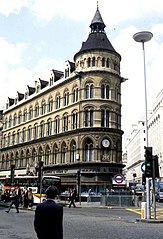
The Mappin & Webb building, London (as was). Designed by John Belcher in 1870, this architectural gem was built to house the offices of the royal silversmiths. Its shape and proportions suited perfectly the crowded space available, and it quickly became a great favourite with visitors approaching the city from the east. In 1968, developers began to make other plans for this site, involving demolition and rebuilding. A massive campaign fought off these plans until 1994 when its replacement - No. 1 Poultry - was erected. See
1229381
|
| Date | |
| Source | From geograph.org.uk |
| Author | Derek Voller |
|
Attribution
( required by the license ) |
Derek Voller / The Mappin & Webb building, London (as was) / |
| Camera location |
|
View this and other nearby images on: OpenStreetMap |
|
|---|
_-_geograph.org.uk_-_1229496.jpg¶ms=051.513460_N_-000.088400_E_globe:Earth_type:camera_source:geograph-osgb36(TQ32748112)_heading:315.00&language=en)
| Object location |
|
View this and other nearby images on: OpenStreetMap |
|
|---|
_-_geograph.org.uk_-_1229496.jpg¶ms=051.513930_N_-000.089200_E_globe:Earth_class:object_type:object_source:geograph-osgb36(TQ32688117)_heading:315.00&language=en)
Licensing

|
This image was taken from the
Geograph project
collection. See
this photograph's page
on the Geograph website for the photographer's contact details. The copyright on this image is owned by
Derek Voller
and is licensed for reuse under the
Creative Commons
Attribution-ShareAlike 2.0 license.
|
This file is licensed under the
Creative Commons
Attribution-Share Alike 2.0 Generic
license.
Attribution:
Derek Voller
-
You are free:
- to share – to copy, distribute and transmit the work
- to remix – to adapt the work
-
Under the following conditions:
- attribution – You must give appropriate credit, provide a link to the license, and indicate if changes were made. You may do so in any reasonable manner, but not in any way that suggests the licensor endorses you or your use.
- share alike – If you remix, transform, or build upon the material, you must distribute your contributions under the same or compatible license as the original.