The_facade_of_the_the_Tomb_of_the_Palmettes,_first_half_of_the_3rd_century_BC,_Ancient_Mieza_(7263674714).jpg

Size of this preview:
450 × 600 pixels
.
Other resolutions:
180 × 240 pixels
|
360 × 480 pixels
|
576 × 768 pixels
|
768 × 1,024 pixels
|
1,536 × 2,048 pixels
|
3,216 × 4,288 pixels
.
Summary
| Description |
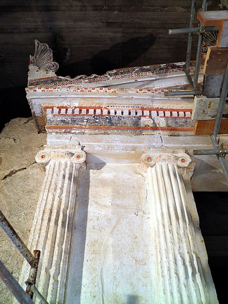
The entrance has crowning mouldings on the interior sides, decorated by coloured Doric and Ionic mouldings and taeniae. There was no dromos leading to the tomb. The present staircase is a modern structure, designed to facilitate visitors and also to support the natural side walls of the excavated trench and prevent the monument from being covered with earth once again. Dimensions of the antechamber: lengh 2, width 408, heigh 5.14m ; dimensions of the main chamber: lengh 5.10, width 4.07, height 4.95m. The facade is 6.25m high, 5.25m wide, and is higher than the roof. The predominant colour on the facade up to the level of the capitals of the Ionic half-columns is white; this is the final thin layer of lime-plaster which was used according to the prevailing custom to cover the surface of the poros blocks, which was full of holes, and make it look like marble. From the level of the capitals upwards a variety of colours is used, the predominant ones being shades of red and blue applied to the individual decorative elements: Ionic and Doric mouldings, frieze, taeniaeeeeem astragals, Lesbian mouldings, and alternating palmettes and lotus flowers, which adorned the raking of the tympanum of the pediment of the Ionic architrave. The pediment ont the facade is crowned by three windblown palmettes with a strong chiaroscuro effect, produced by the deep relief of the leaves and the triangular tongue-heart at its center, with deep blue between the white-ochre and slightly pink leaves, and deep pink and red at the heart in the centre. |
| Date | |
| Source |
The facade of the the Tomb of the Palmettes, first half of the 3rd century BC, Ancient Mieza
|
| Author | Carole Raddato from FRANKFURT, Germany |
| Camera location |
|
View this and other nearby images on: OpenStreetMap |
|
|---|
.jpg¶ms=040.651471_N_0022.116680_E_globe:Earth_type:camera_source:Flickr_&language=en)
Licensing
This file is licensed under the
Creative Commons
Attribution-Share Alike 2.0 Generic
license.
-
You are free:
- to share – to copy, distribute and transmit the work
- to remix – to adapt the work
-
Under the following conditions:
- attribution – You must give appropriate credit, provide a link to the license, and indicate if changes were made. You may do so in any reasonable manner, but not in any way that suggests the licensor endorses you or your use.
- share alike – If you remix, transform, or build upon the material, you must distribute your contributions under the same or compatible license as the original.
|
|
This image, originally posted to Flickr , was reviewed on 15 December 2013 by the administrator or reviewer File Upload Bot (Magnus Manske) , who confirmed that it was available on Flickr under the stated license on that date. |
|
|
This media file is in the
public domain
in the
United States
. This applies to U.S. works where the copyright has expired, often because its first
publication
occurred prior to January 1, 1929, and if not then due to lack of notice or renewal. See
this page
for further explanation.
|

|

|
This image might not be in the public domain outside of the United States; this especially applies in the countries and areas that do not apply the
rule of the shorter term
for US works, such as Canada, Mainland China (not Hong Kong or Macao), Germany, Mexico, and Switzerland. The creator and year of publication are essential information and must be provided. See
Wikipedia:Public domain
and
Wikipedia:Copyrights
for more details.
|
|
|
This work is in the public domain in its country of origin and other countries and areas where the copyright term is the author's life plus 100 years or fewer . |
| This file has been identified as being free of known restrictions under copyright law, including all related and neighboring rights. | |