The_wars_of_Matthias_Corvinus_of_Hungary_(1458-1490).png

Size of this preview:
597 × 599 pixels
.
Other resolutions:
239 × 240 pixels
|
478 × 480 pixels
|
765 × 768 pixels
|
1,020 × 1,024 pixels
|
1,700 × 1,707 pixels
.
Summary
| Description |
English:
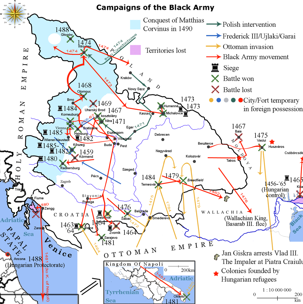
Map showing the direction of attacks in/of Hungary and in/of the surrounding countries in the middle of 15th century concentrating on the Black Army of Hungary.
|
| Date | |
| Source | own work based on the map Map of Hungary in 1490 . Historical information is taken from Történelmi világatlasz, Budapest, Hungary, 1991, Kartográfiai Vállalat, ISBN 963-351-696-X -CM and Fenyvesi, László (1990). Mátyás Király fekete serege, Budapest, Hungary: Zrínyi Katonai Kiadó. ISBN 9633260170 Invalid ISBN . |
| Author | Viztarp ( talk · contribs ), Alex:D ( talk · contribs ) |
Licensing
Lajbi
at
English Wikipedia
, the copyright holder of this work, hereby publishes it under the following license:
This file is licensed under the
Creative Commons
Attribution 3.0 Unported
license.
Attribution:
Lajbi
at
English Wikipedia
-
You are free:
- to share – to copy, distribute and transmit the work
- to remix – to adapt the work
-
Under the following conditions:
- attribution – You must give appropriate credit, provide a link to the license, and indicate if changes were made. You may do so in any reasonable manner, but not in any way that suggests the licensor endorses you or your use.
Original upload log
The original description page was
here
. All following user names refer to en.wikipedia.
| Date/Time | Dimensions | User | Comment |
|---|---|---|---|
| 2010-10-20 11:26 | 1700×1707× (652065 bytes) | Lajbi | distinguished Nitra from Kosztolány - corrected Moldvian campaign route |
| 2010-10-19 11:31 | 1700×1707× (649221 bytes) | Lajbi | colored the mini map - fixed the dates - added the HUungarian colonies - added Vlad Tepes' arrest |
| 2010-10-12 21:45 | 1700×1707× (631386 bytes) | Lajbi | Added coast of the Black Sea with the Danube Delta - Colored water - Added "Lost territories" |
| 2010-10-11 16:05 | 1500×1707× (577525 bytes) | Lajbi | *Fixed southern border *Added Battle of Timisosara in 1484 *Added port of Zengg as a starting place for maritine campaigns *Added first Polish intervention *Added northern powlings of Hungarian light cavalry *Added more temporary changes in cities ownersh |
| 2010-10-08 12:50 | 1500×1707× (542278 bytes) | Lajbi | {{Information |Description=Map showing the direction of attacks in/of Hungary and in/of the surrounding countries in the middle of 15th century concentrating on the Black Army of Hungary. |Source=own work based on the map [[File:Map of Hungary in 1490.png |